
← Terraforming · Water & diversion
Aral Sea diversions
Cotton took the rivers. The world’s fourth-largest lake became a desert. The North Aral has a small, engineered second life. The south does not.

Jurisdiction: Soviet Union, then Kazakhstan and Uzbekistan (Amu Darya / Syr Darya basin)
Years / status: Large-scale irrigation expansion from the 1960s. Collapse through the 1980s-2000s. Kokaral Dam 2005. Status: failed as a sea; partial northern recovery.
The plan
Soviet planners diverted the Amu Darya and Syr Darya into desert irrigation: especially cotton: treating the Aral as a leftover. The goal was export fibre and new sovkhoz acreage, not a living sea. Inflow fell while evaporation continued.
Construction / status
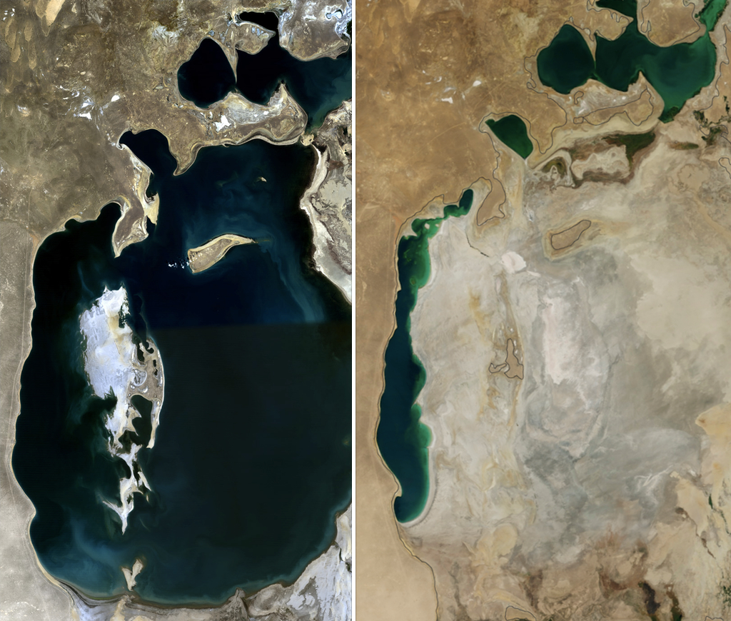
Canals, including the Karakum Canal, and on-farm networks were built at continental scale. Efficiency was poor; a large share of river water never reached a root. The shoreline walked away from the ports of Aralsk and Moynaq within a generation. NASA time series show the lake splitting and the southern basin largely emptying.
What went wrong, or only partly worked
The Aral lost on the order of 90 percent of its water. Dust from the new Aralkum desert carries salt and residues. Fisheries collapsed. Kazakhstan, with World Bank support, finished the Kokaral Dam in 2005 to hold Syr Darya water in the North Aral: levels rose, salinity fell, and a smaller fishery returned (later reporting cites several thousand tonnes a year: a recovery, not the old industrial catch). The South Aral remains mostly dry. Full restoration of the 1960 sea is not on offer.
Lessons
A river is not surplus. Irrigation “losses” are someone else’s lake. Partial recovery is possible when one basin is walled off and inflows are defended, and it is still a smaller sea. Downstream dust and health in Karakalpakstan remain a cost of the original plan.
Sources
NASA Earth Observatory World of Change: Shrinking Aral Sea; World Bank Syr Darya Control and Northern Aral Sea Project; 2026 reporting on North Aral water volume and southern dust.