
Mangroves
Where mangrove forests grow along tropical coasts and how their area has changed over four decades. Global Mangrove Watch reports a net gain of 47,707 hectares worldwide from 1985 to 2025, with large losses in some countries and gains in others.
Extent and change · 1985 to 2025
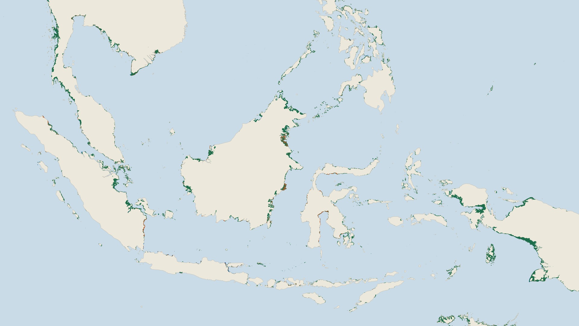
Mangrove extent in Southeast Asia and New Guinea in 1996 and 2020, from the 1996 to 2020 edition of Global Mangrove Watch. Green is mangrove in both years, orange is mangrove in 1996 only, and blue is mangrove in 2020 only. Each cell shows the share of its area covered by mangrove.
Map by Fix Planet from Global Mangrove Watch data for 1996 and 2020 (Bunting and others, 2022), shared through the Esri Living Atlas. ©Global Mangrove Watch. Coastline: Natural Earth, public domain (https://www.naturalearthdata.com/about/terms-of-use/). Licence: Creative Commons Attribution 4.0 International, https://creativecommons.org/licenses/by/4.0/
What it is
Mangroves are forests of salt-tolerant trees that grow where tropical and subtropical coasts are flooded by the tide. Global Mangrove Watch is a partnership led by Aberystwyth University, solo Earth Observation, Wetlands International, The Nature Conservancy and the Japan Aerospace Exploration Agency. Its latest update gives a map of mangrove extent for each year from 1985 to 2025, 41 annual maps in all, made from optical satellite images and from long-wavelength radar images. The newest baseline maps show detail down to 10 metres, and the maps of loss and recovery show detail down to 30 metres.
Why it matters
Mangroves protect coastal communities from storm surges and sea level rise, support fish and livelihoods, shelter rich wildlife and, according to Wetlands International, store carbon at rates up to four times higher per hectare than forests on land. Global Mangrove Watch reports that 147,283 km² of mangroves remain, in 128 countries and territories. Between 1985 and 2025 the world gained a net 47,707 hectares of mangrove cover, which is 477 km². That total is a balance across countries. India gained 1,180 km² and Australia gained 1,396 km², while Indonesia, which has the largest mangrove area, lost a net 2,043 km² since 1985, and Myanmar lost 1,457 km².
How to read it
The map shows Southeast Asia and New Guinea, a region that includes Indonesia, using the earlier edition of the data for 1996 and 2020. Green marks mangrove present in both years, orange marks mangrove present in 1996 but gone by 2020, and blue marks mangrove absent in 1996 and present in 2020. Each map cell shows the share of its area covered by mangrove, so thin fringes look faint. The world figures in the text come from the latest update, which covers 1985 to 2025 and keeps gross loss and gross gain in separate layers, so clearing in one place can be seen apart from regrowth in another. The accuracy of the latest baseline maps is estimated at 93 percent.
Limits
A net gain of 477 km² worldwide is small beside the 147,283 km² that remain, and it hides large local losses. Wetlands International says that gains lie mostly around rivers and deltas and may follow human activity upstream, such as mining and deforestation, which changes the flow of water and sediment. Another part of the gain comes from natural regrowth, planting and restoration. Maps of the 1980s and 1990s rest on fewer satellite images in some regions, so the early years are less certain. The two editions of the data give different results, so a figure is best quoted together with its edition.
Sources
- Global Mangrove Watch: platform for exploring the maps : https://www.globalmangrovewatch.org/
- Wetlands International: Good news for mangroves globally masks big losses in some regions, according to updated Global Mangrove Watch (23 July 2026) : https://www.wetlands.org/good-news-for-mangroves-globally-masks-big-losses-in-some-regions-according-to-updated-global-mangrove-watch/
- Japan Aerospace Exploration Agency, Earth Observation Research Center: Global Mangrove Watch dataset : https://www.eorc.jaxa.jp/ALOS/en/dataset/gmw_e.htm
- Global Mangrove Alliance: Global Mangrove Watch 4.1 Launch : https://www.mangrovealliance.org/news/global-mangrove-watch-4-launch
- Esri Living Atlas: Global Mangrove Watch Time Series (1996 to 2020 edition, source of the map) : https://www.arcgis.com/home/item.html?id=3a08770f1929427fb7d33d509d27969e