
Seagrass meadows
Where seagrass meadows have been mapped along the world’s coasts and how large the mapped area is. A 2020 global assessment found 160,387 km² mapped with moderate to high confidence, in 103 countries and territories.
Mapped area · 2020 global assessment
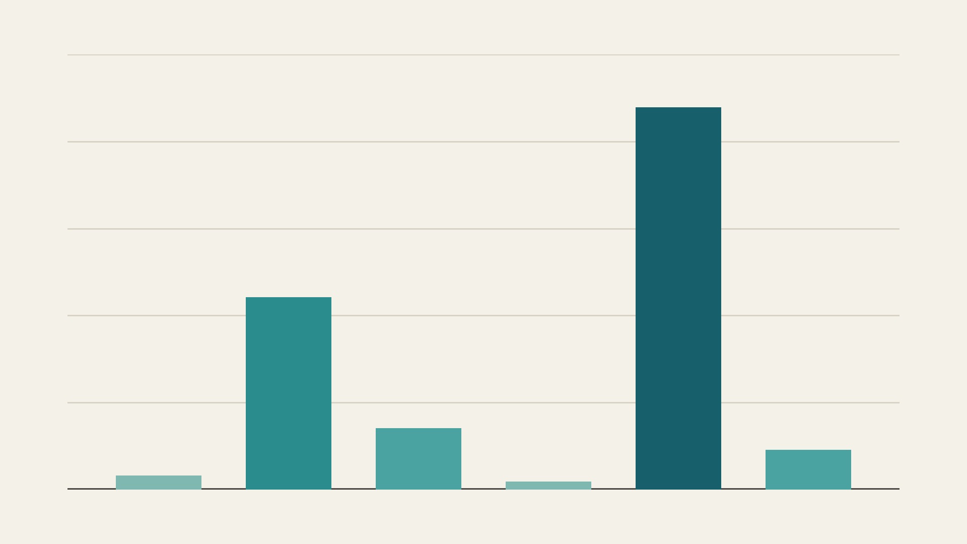
Seagrass area mapped with moderate to high confidence in six seagrass regions, from a 2020 global assessment. From left to right: temperate North Atlantic 3,229 km², tropical Atlantic 44,222, Mediterranean 14,167, a second temperate northern region 1,866, tropical Indo-Pacific 87,791 and temperate southern oceans 9,112. Gridlines mark every 20,000 km².
Chart by Fix Planet from Table 1 of McKenzie and others, 2020, The global distribution of seagrass meadows, Environmental Research Letters 15, 074041. Licence: Creative Commons Attribution 4.0 International, https://creativecommons.org/licenses/by/4.0/
What it is
Seagrasses are flowering plants that grow in shallow coastal seas and form underwater meadows. The most extensive collection of seagrass maps is held by the United Nations Environment Programme World Conservation Monitoring Centre. In 2020 McKenzie and colleagues merged those maps with other public maps into a country by country estimate of seagrass area, published in Environmental Research Letters. For the area estimates they used only mapped areas, and they used point records, such as herbarium specimens, only to show that seagrass is present.
Why it matters
According to the study, seagrass meadows are a major store of carbon and a habitat for fish, and hundreds of millions of people rely on them for food and livelihoods. Its estimate is 160,387 km² of seagrass mapped with moderate to high confidence in 103 countries and territories, plus another 106,175 km² with low confidence in 33 more countries, which together make 266,562 km². Australia has the largest compiled area, 83,013 km², which is over 31 percent of the known total. Earlier estimates in the literature ranged from 177,000 to 600,000 km².
How to read it
Each bar is the area mapped with moderate to high confidence in one of six seagrass regions, in the order of the study’s table: temperate North Atlantic 3,229 km², tropical Atlantic 44,222, Mediterranean 14,167, a second temperate northern region 1,866, tropical Indo-Pacific 87,791 and temperate southern oceans 9,112. The six bars add up to 160,387 km². Where several maps overlap, the overlap was counted once, and parts of maps deeper than 200 metres were removed.
Limits
Mapped area is the area that someone has mapped, which is smaller than the area of seagrass that exists. The study names large coasts that remain poorly mapped, including insular Southeast Asia, the east coast of South America and the west coast of Africa, and it says the Philippines are suspected to hold vast meadows that are largely uncharted. The underlying maps date from 1930 to 2015 and range from expert sketches to field validated surveys, so quality differs from country to country. The numbers give one compiled picture and cannot show whether seagrass area has grown or shrunk.
Sources
- McKenzie and others: The global distribution of seagrass meadows (Environmental Research Letters, 2020, open access PDF) : https://www.seagrasswatch.org/wp-content/uploads/Resources/Publications/2020/PDF/McKenzie-et-al_2020.pdf
- United Nations Environment Programme World Conservation Monitoring Centre: Global Distribution of Seagrasses (data record, 2021 edition) : https://resources.unep-wcmc.org/products/aaa46cd3d3d640b2916b8f0a0ffe07cb