
Salt marshes
How much tidal salt marsh has been mapped worldwide. A 2017 global map records 5,495,089 hectares of salt marsh in 43 countries and territories, and notes occurrences in 99 countries.
Recorded extent · 2017 global map
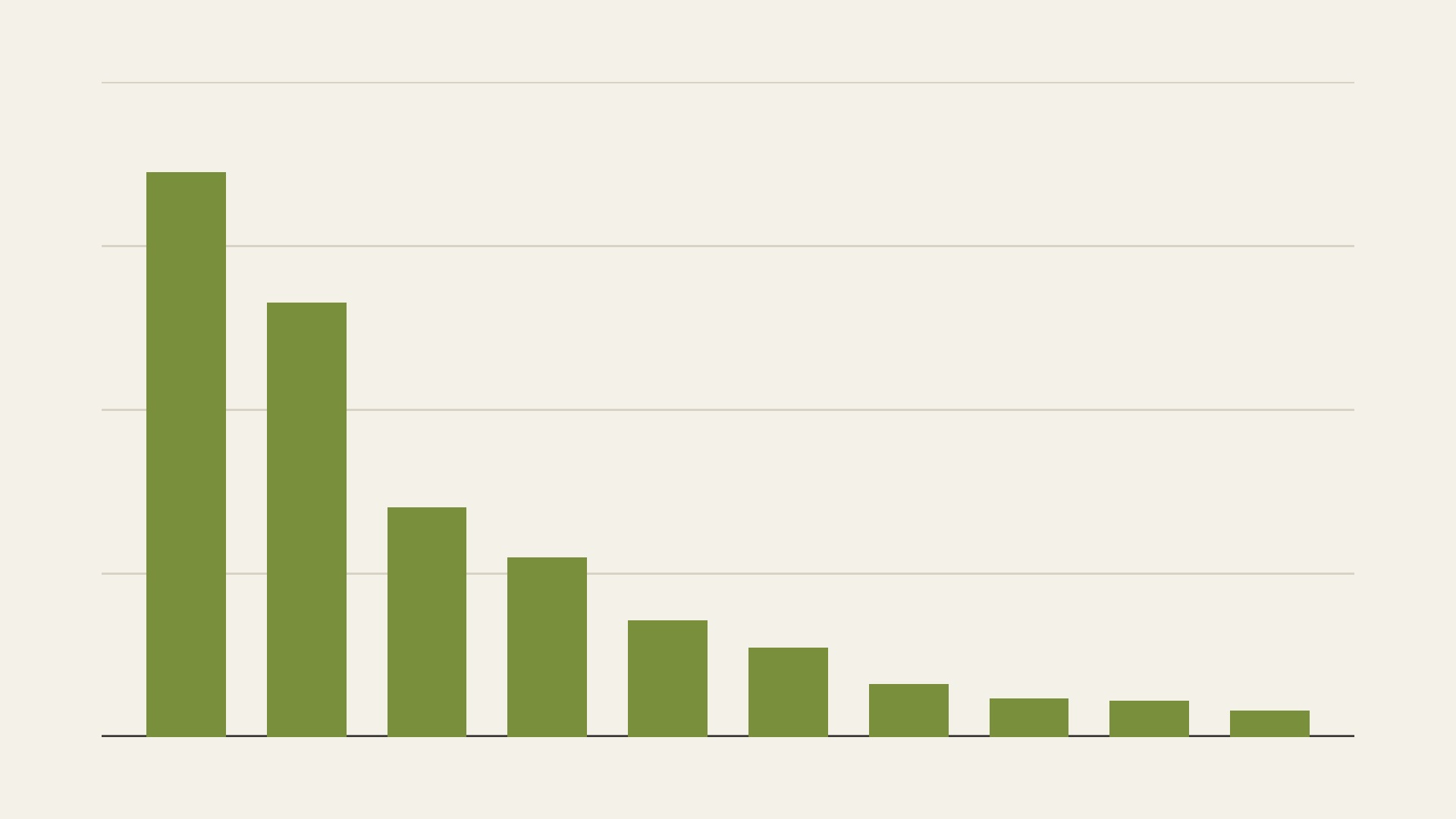
Recorded salt marsh area in hectares for the ten largest entries in the table of a 2017 global map. From left to right: the United States mainland and Hawaii, Australia, the Russian Federation, China, mainland Europe, Mexico, Alaska, Argentina, Canada and Great Britain. Gridlines mark every 500,000 hectares.
Chart by Fix Planet from Table 1 of Mcowen and others, 2017, A global map of saltmarshes, Biodiversity Data Journal 5, e11764. Licence: Creative Commons Attribution 4.0 International, https://creativecommons.org/licenses/by/4.0/
What it is
Salt marshes are coastal wetlands on sheltered shores, where herbs, grasses and low shrubs that tolerate salt are flooded by the tides. They occur worldwide, mostly in middle and high latitudes, and the most extensive ones lie outside the tropics, notably around the North Atlantic. In 2017 Mcowen and colleagues published a global dataset of salt marsh occurrence and extent in the Biodiversity Data Journal, with the first global estimate of the known extent. It collects 350,985 individual occurrences, and the United Nations Environment Programme World Conservation Monitoring Centre curates and distributes it.
Why it matters
Salt marshes shelter fish, birds and many other animals, buffer shores against waves, erosion and storm surges, filter runoff and store carbon. The dataset records salt marsh in 99 countries. Its mapped outlines cover 5,495,089 hectares, which is 54,951 km², in 43 countries and territories. That total is at the low end of earlier estimates, which ranged from 2.2 to 40 million hectares, because the authors took a conservative approach to mapping.
How to read it
Each bar is the recorded extent, in hectares, of one of the ten largest entries in the paper’s table. From left to right: the United States mainland and Hawaii 1,723,410; Australia 1,325,854; the Russian Federation 700,719; China 549,506; mainland Europe, 20 countries together, 356,947; Mexico 272,527; Alaska 161,483; Argentina 118,870; Canada 111,274; and Great Britain 81,842. Gridlines mark every 500,000 hectares. The entries come from surveys made between 1973 and 2015, most of them after 2005, and overlapping outlines were merged before the areas were added.
Limits
The total is a minimum. The authors name regions where salt marsh is known but lacks mapped outlines, including Canada, northern Russia, South America and Africa. They say the outlines cover many of the important areas in Europe, the United States and Australia, so bars for those places are more complete than bars for places with less mapping. The dataset records where and when mapping was done and cannot show change from year to year.
Sources
- Mcowen and others: A global map of saltmarshes (Biodiversity Data Journal, 2017) : https://bdj.pensoft.net/article/11764/
- United Nations Environment Programme World Conservation Monitoring Centre: Global Distribution of Saltmarshes (data record) : https://resources.unep-wcmc.org/products/addd1baa160c4d318b84c3b714d3e583