← Maps

Map room · early centuries CE

Religions

A shelf of flat schematics for the early centuries CE. Religion fills are Fix Planet reconstructions. Later centuries keep their earlier source plates.

There is no single “true” world religion map for antiquity. Belief, practice, and state cult overlap; most people were never counted. These plates are coarse Old-World washes, not a headcount and not a map of official state religions. The Reclus 1905 plate remains a museum companion. The AD 600 Christianity process plate stays on the shelf as a companion, not as the multi-religion schematic for those centuries.

Shared legend

  • Roman civic / pagan
  • Christian (dot / hatch)
  • Islam
  • Jewish communities
  • Zoroastrian-leaning
  • Hindu umbrella
  • Buddhist corridors
  • Chinese imperial
  • Dao / folk (merged)
  • Manichaean (hatch)
  • African traditions
  • Local traditions
  • Unmapped (not invented)
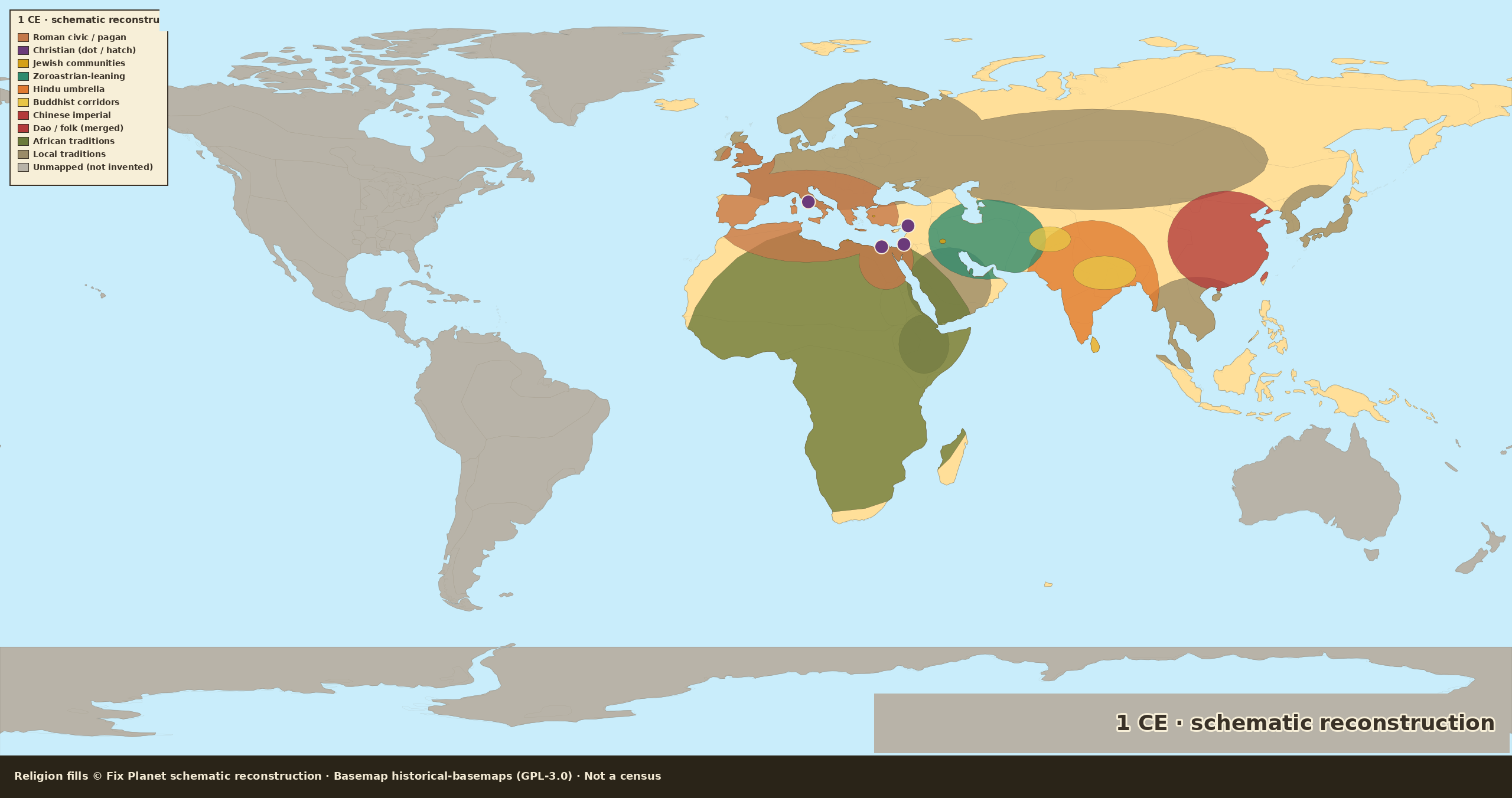
Schematic world religion map for 1 CE: Roman pagan Mediterranean, tiny Christian dots, Parthian zoroastrian wash, Indic and Han umbrellas, Americas unmapped gray
Fix Planet schematic reconstruction. Map dated: 1 CE schematic.
Schematic reconstructionNot a censusOld World focusAmericas not shown

1 CE: schematic reconstruction

A Fix Planet schematic of named traditions at the start of the Common Era. Rome’s official civic cults colour the Mediterranean; Christianity is four urban dots: Palestine, Antioch, Rome, Alexandria, not an empire-wide fill. Focus is the Old World; the Americas and Oceania stay unmapped.

Fix Planet hand-authored schematic: Old World / Mediterranean focus; Americas and Oceania stay unmapped

By continent

Europe

Imperial and civic paganism from Britain and Gaul through Italy, the Balkans, and Anatolia. Jewish communities sit as spots in Rome and the eastern cities. Christian presence is a handful of house-churches, too small to paint a province. North of the limes, local traditions stay a coarse wash. Do not read the terracotta as “everyone believed the same thing.”

Africa

Egypt and the Maghreb sit in the Roman civic-cult layer, with a Jewish and a tiny Christian mark at Alexandria. South of the Sahara the sheet uses one African-traditions wash, a label of ignorance, not a census of cults. Aksum is not painted Christian.

Asia

Parthia is zoroastrian-leaning, not a sealed state church. Judea and the eastern diaspora are jewish spots. India is a hindu wash with buddhist corridors along the Ganges, Sri Lanka, and Gandhara. Han China is Chinese imperial; Dao / folk is merged with that fill. Steppe and Arabia stay local traditions.

Americas

Unmapped gray. We do not invent a religion layer for the Americas in year 1.

Oceania

Unmapped gray. Australia and the Pacific are not filled as religions on this plate.
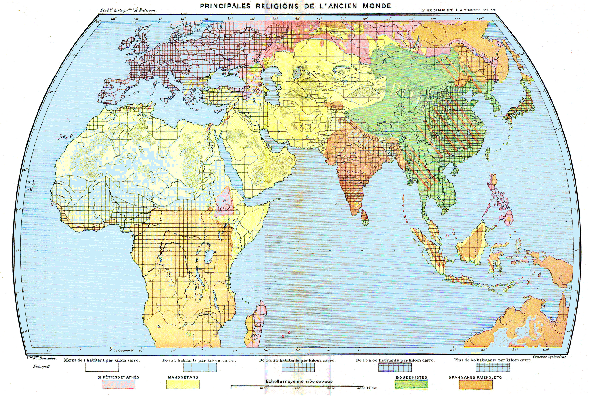
Museum companion: Reclus 1905 Old-World plate (public domain)

Source

Fix Planet schematic reconstruction
Map dated: 1 CE schematic
Religion fills © Fix Planet (schematic reconstruction, not a census). Basemap: Historical Basemaps, André Ourednik, GPL-3.0 licence. Optional museum companion: Élisée Reclus, L’Homme et la Terre (1905), public domain.

License

Schematic religion fills © Fix Planet. Historical Basemaps, André Ourednik, GPL-3.0 licence
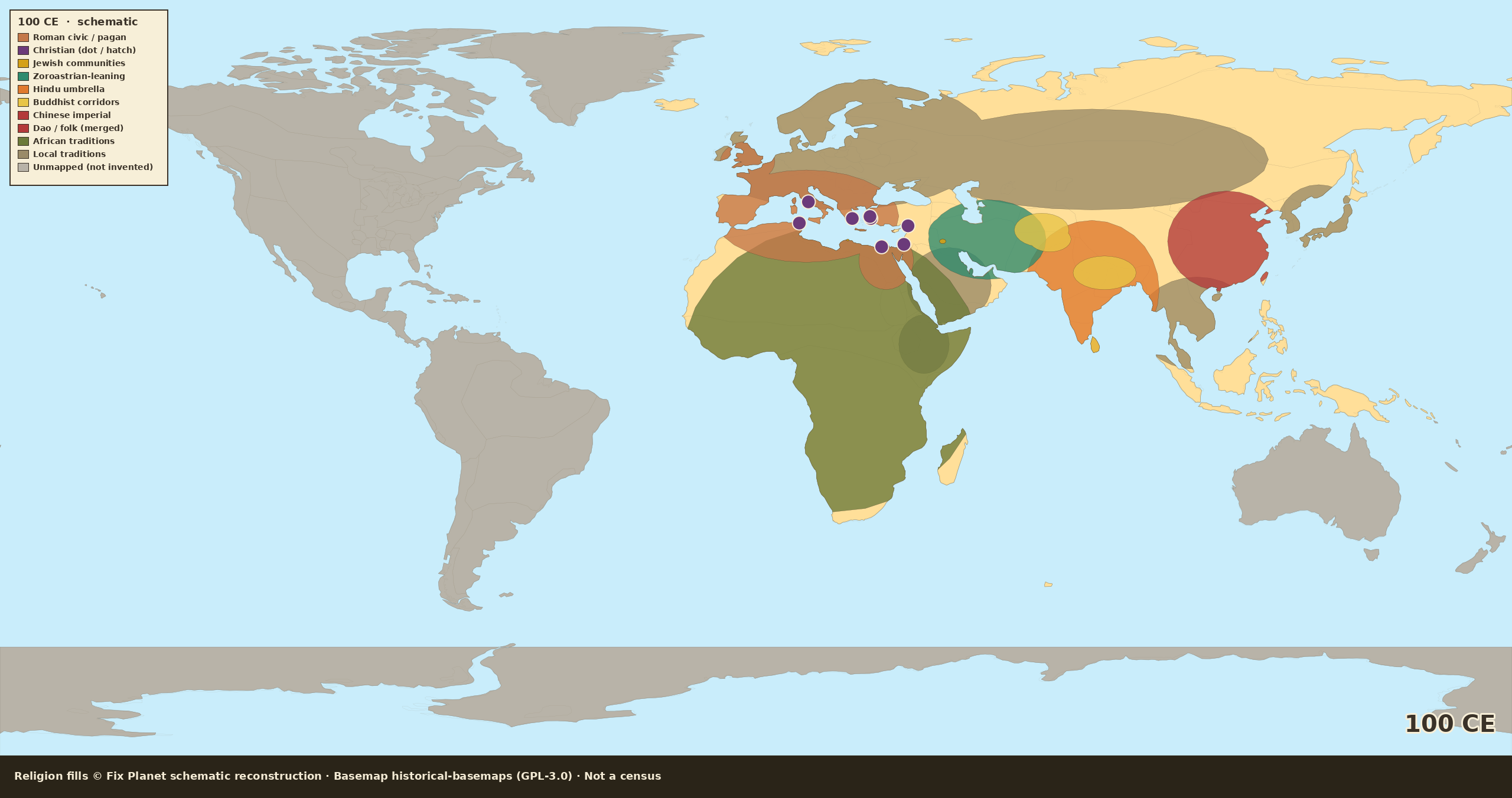
Schematic world religion map for 100 CE: pagan Mediterranean, slightly more Christian urban dots, Kushan Buddhist mix, Americas unmapped
Fix Planet schematic reconstruction. Map dated: 100 CE schematic.
Schematic reconstructionNot a censusOld World focusAmericas not shown

100 CE: Trajan still pagan

Same Old-World umbrellas as year 1. Trajan’s Rome is still officially pagan; we do not paint the empire Christian. A few more urban Christian dots (Ephesus, Corinth, Carthage, Smyrna) join the first four. The Kushan world is an Indic-Buddhist mix, not a single state colour.

Fix Planet hand-authored schematic: Old World / Mediterranean focus; Americas and Oceania stay unmapped

By continent

Europe

The high empire is still civic pagan on this sheet. Extra Christian dots mark named cities, not provinces. Jewish spots remain. Northern and forest Europe stay local traditions. No Christian empire colour.

Africa

North Africa remains in the Roman pagan wash, with a Christian dot at Carthage and Alexandria. The Sahara-south African-traditions wash is unchanged, still not a village survey.

Asia

Parthia stays zoroastrian-leaning. Kushan lands take a buddhist/Indic mix over the hindu umbrella. Han China remains Chinese imperial. Silk-road Buddhist corridors are still thin.

Americas

Still unmapped. We do not invent fills because a century has passed.

Oceania

Still unmapped gray.

Source

Fix Planet schematic reconstruction
Map dated: 100 CE schematic
Religion fills © Fix Planet (schematic reconstruction, not a census). Basemap: Historical Basemaps, André Ourednik, GPL-3.0 licence.

License

Schematic religion fills © Fix Planet. Historical Basemaps, André Ourednik, GPL-3.0 licence
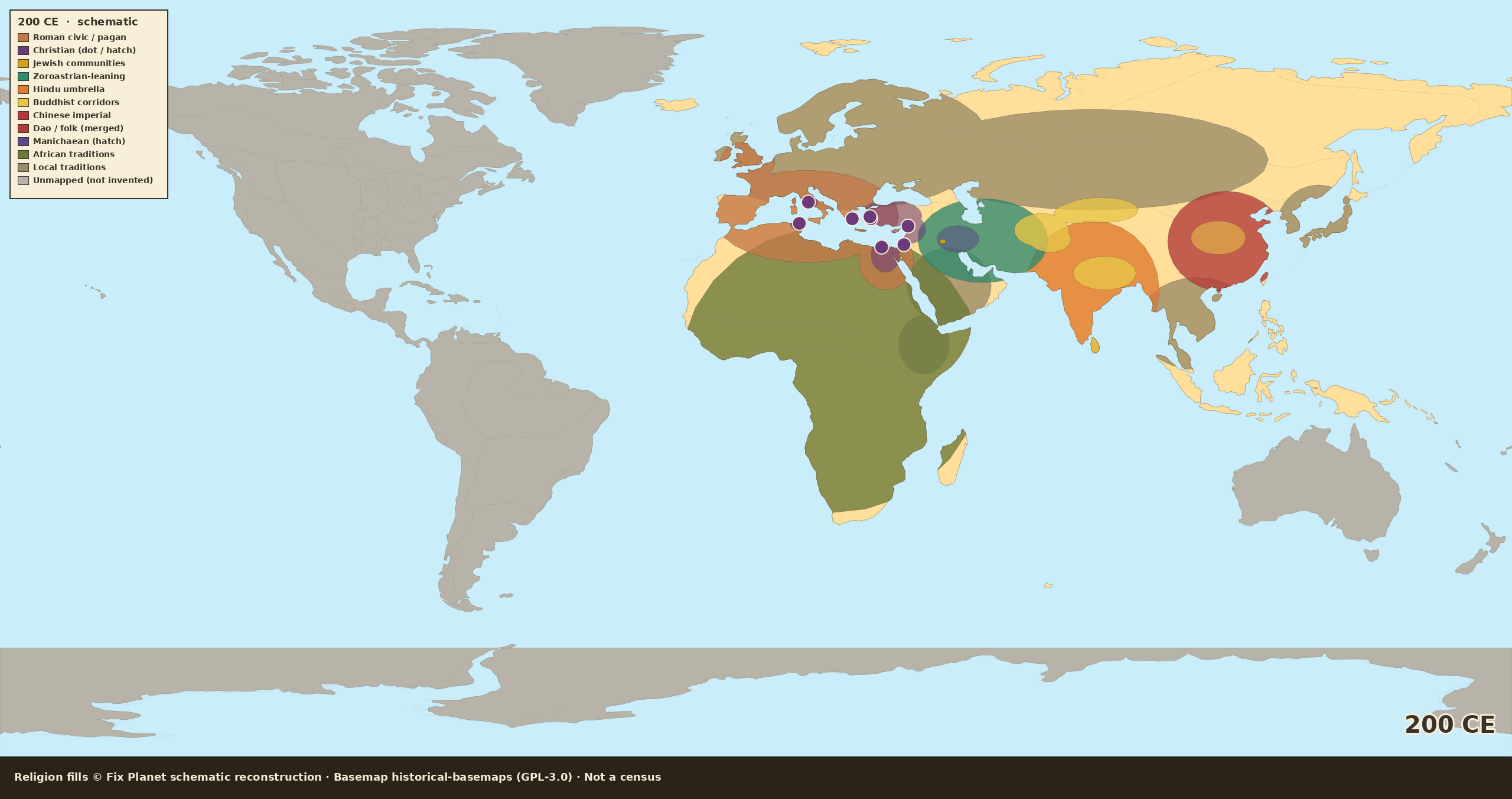
Schematic world religion map for 200 CE: pagan Rome, Christian urban hatch, Sasanian zoroastrian, Silk Road Buddhist, Americas unmapped
Fix Planet schematic reconstruction. Map dated: 200 CE schematic.
Schematic reconstructionNot a censusOld World focusAmericas not shown

200 CE: official pagan, denser Christian cities

Rome is still officially pagan. Christianity shows as denser urban hatch across Syria, Asia Minor, Egypt, Rome, and Carthage, not a Mediterranean fill. A thin manichaean hatch appears in Mesopotamia. Sasanian Iran is a stronger zoroastrian wash. Buddhist corridors thicken on the Silk Road; China stays imperial with Buddhist inroads.

Fix Planet hand-authored schematic: Old World / Mediterranean focus; Americas and Oceania stay unmapped

By continent

Europe

The official colour is still Roman civic / pagan. Christian hatch sits on Rome and a few western cities. Rural West is not a church map. Local traditions north of the limes stay coarse.

Africa

Carthage and Egypt carry Christian urban hatch over a pagan official layer. Sub-Saharan African traditions are unchanged. No invented Christian Nubia on this step.

Asia

Sasanian Iran is a stronger zoroastrian umbrella. Manichaean hatch is minority only, in Mesopotamia and southwest Iran. Buddhist washes follow Gandhara, Bactria, and the Tarim. Han/successor China is imperial, with a Buddhist hatch in the interior, not a Buddhist empire.

Americas

Unmapped gray. Americas are not invented.

Oceania

Unmapped gray.

Source

Fix Planet schematic reconstruction
Map dated: 200 CE schematic
Religion fills © Fix Planet (schematic reconstruction, not a census). Basemap: Historical Basemaps, André Ourednik, GPL-3.0 licence.

License

Schematic religion fills © Fix Planet. Historical Basemaps, André Ourednik, GPL-3.0 licence
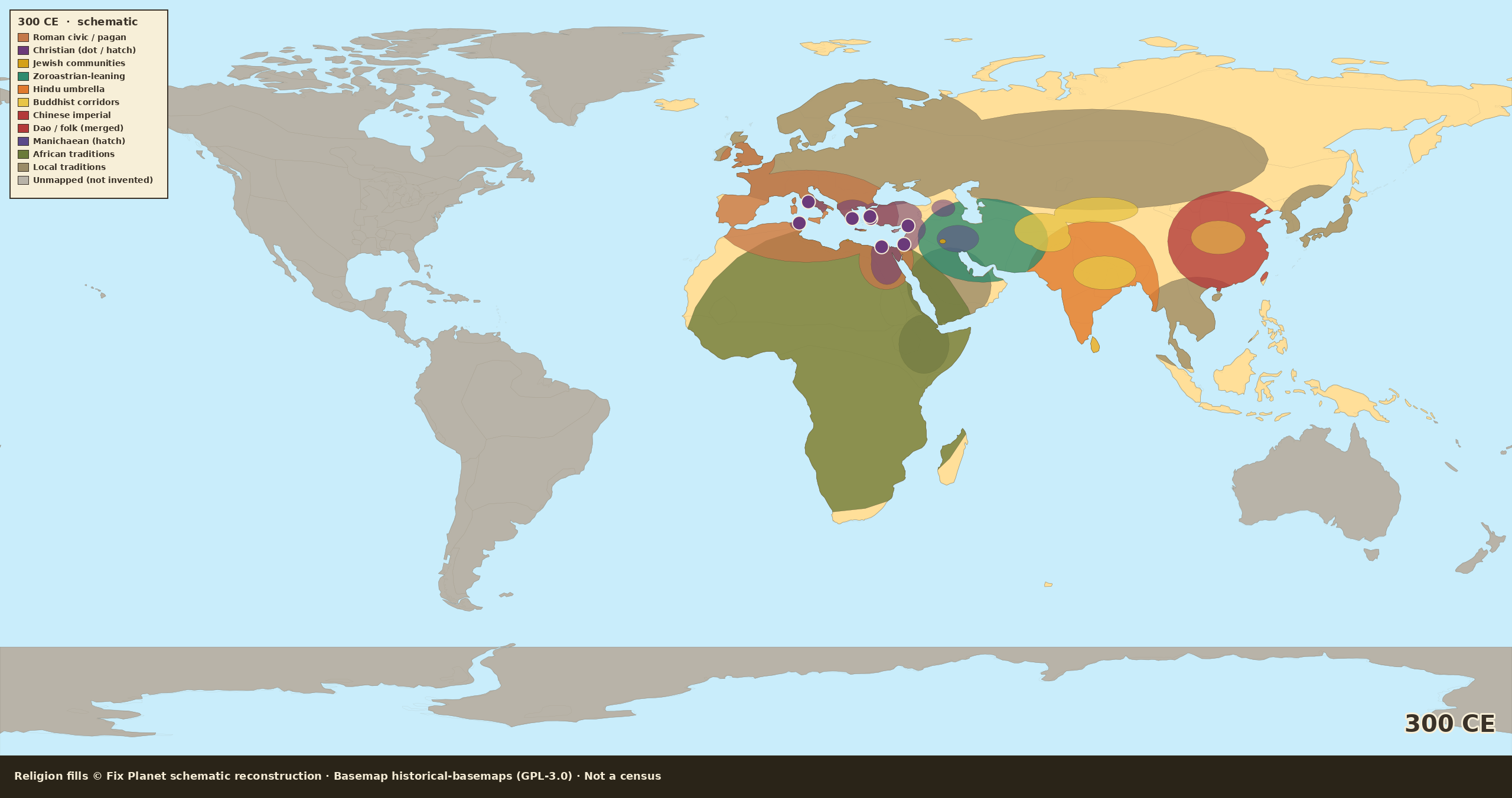
Schematic world religion map for 300 CE: pagan majority around Rome, Christian urban minority in the East, Armenia edge, Americas unmapped
Fix Planet schematic reconstruction. Map dated: 300 CE schematic.
Schematic reconstructionNot a censusOld World focusAmericas not shown

300 CE: eve of Constantine, majority pagan

On the eve of Constantine the Mediterranean is still majority pagan on this sheet. Christianity is a large urban minority in the East, hatch and partial colour, not a whole-empire Christian fill. Armenia is an optional Christian edge. Iran stays zoroastrian; India and China keep their umbrellas.

Fix Planet hand-authored schematic: Old World / Mediterranean focus; Americas and Oceania stay unmapped

By continent

Europe

West and much of the Balkans stay Roman civic / pagan. Eastern cities (Greece, Anatolia) take a Christian hatch. This is not “the empire is Christian.” Rural pagan practice is the default outside those hatches.

Africa

Egypt and Carthage show Christian urban hatch over a pagan official layer. Sub-Saharan African traditions are still one coarse wash. No Aksum Christian fill yet.

Asia

Armenia is a cautious Christian edge. Iran is zoroastrian. India remains a hindu umbrella with buddhist corridors. China is Chinese imperial with Buddhist inroads. Manichaean hatch stays minority.

Americas

Unmapped gray. Americas are not invented.

Oceania

Unmapped gray.

Source

Fix Planet schematic reconstruction
Map dated: 300 CE schematic
Religion fills © Fix Planet (schematic reconstruction, not a census). Basemap: Historical Basemaps, André Ourednik, GPL-3.0 licence. Process companion: Christianity spread to AD 600 (CC BY-SA 3.0).

License

Schematic religion fills © Fix Planet. Historical Basemaps, André Ourednik, GPL-3.0 licence
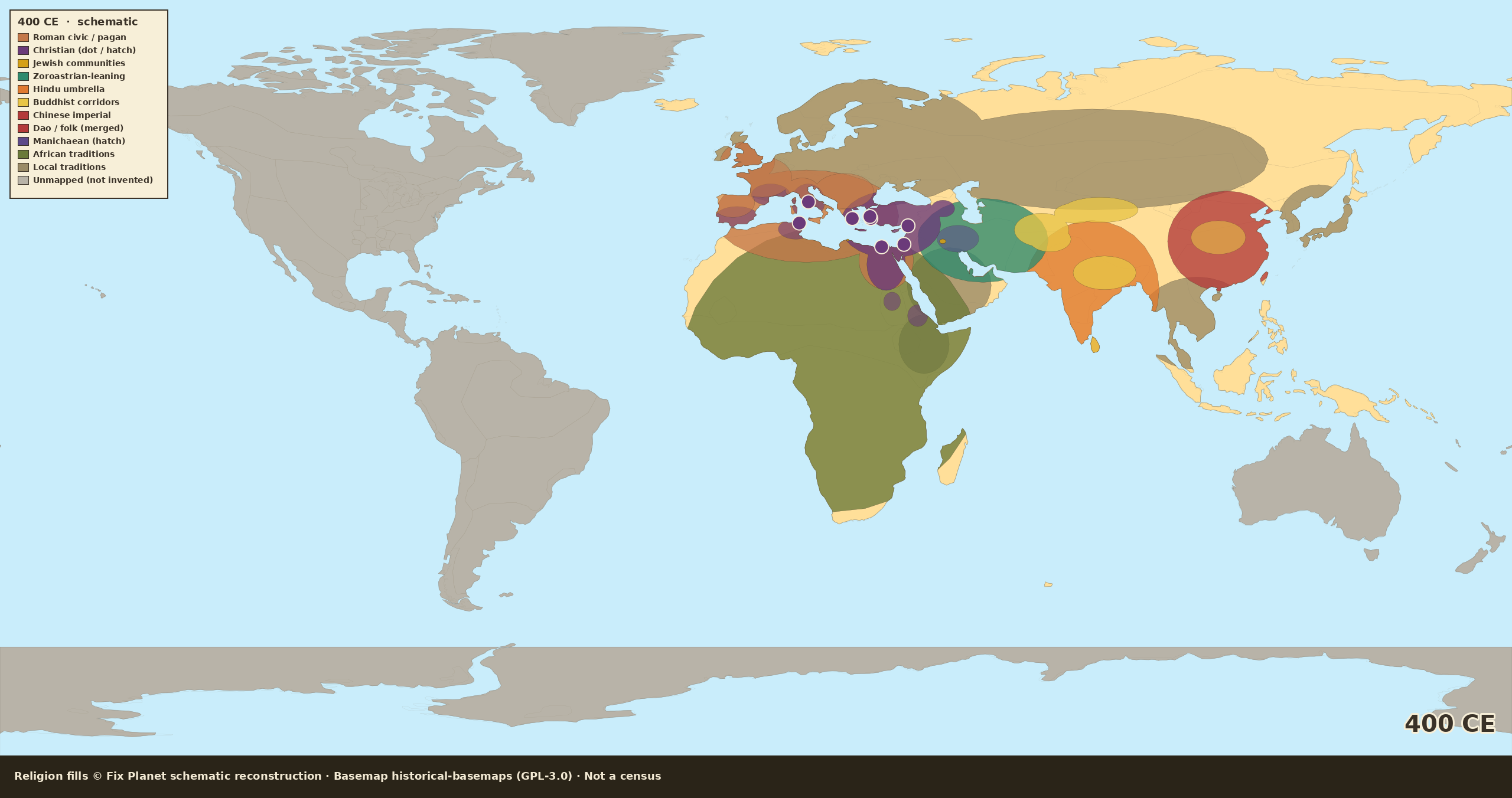
Schematic world religion map for 400 CE: Christian East and western urban belts, rural pagan hatch, zoroastrian Iran, Americas unmapped
Fix Planet schematic reconstruction. Map dated: 400 CE schematic.
Schematic reconstructionNot a censusOld World focusAmericas not shown

400 CE: post-Theodosius, not all Europe Christian

After Theodosius, Christianity expands among eastern and western elites and cities. Rural pagan hatch remains in Gaul, Britain, and interior Balkans: we do not paint all Europe solid Christian. Iran stays zoroastrian. Nubia and Aksum are optional cautious Christian edges. Americas stay unmapped.

Fix Planet hand-authored schematic: Old World / Mediterranean focus; Americas and Oceania stay unmapped

By continent

Europe

East (Greece, Anatolia) reads more Christian. Italy, southern Gaul, and coastal Iberia show urban/elite Christian hatch over a still-pagan countryside. Germania and Scandinavia stay local traditions. This is not a solid Christian Europe.

Africa

Egypt and Roman Africa carry a stronger Christian urban mark. A cautious Christian edge is allowed at Nubia and Aksum, optional, not a painted kingdom. The rest of the continent stays African traditions.

Asia

Iran remains zoroastrian. Armenia keeps a Christian edge. India and China keep hindu and imperial umbrellas, with Buddhist corridors and inroads. No Islamic layer: it does not belong on a 400 plate.

Americas

Still unmapped gray. We do not invent an American religion choropleth.

Oceania

Still unmapped gray.

Source

Fix Planet schematic reconstruction
Map dated: 400 CE schematic
Religion fills © Fix Planet (schematic reconstruction, not a census). Basemap: Historical Basemaps, André Ourednik, GPL-3.0 licence. Process companion: Christianity spread to AD 600 (CC BY-SA 3.0).

License

Schematic religion fills © Fix Planet. Historical Basemaps, André Ourednik, GPL-3.0 licence
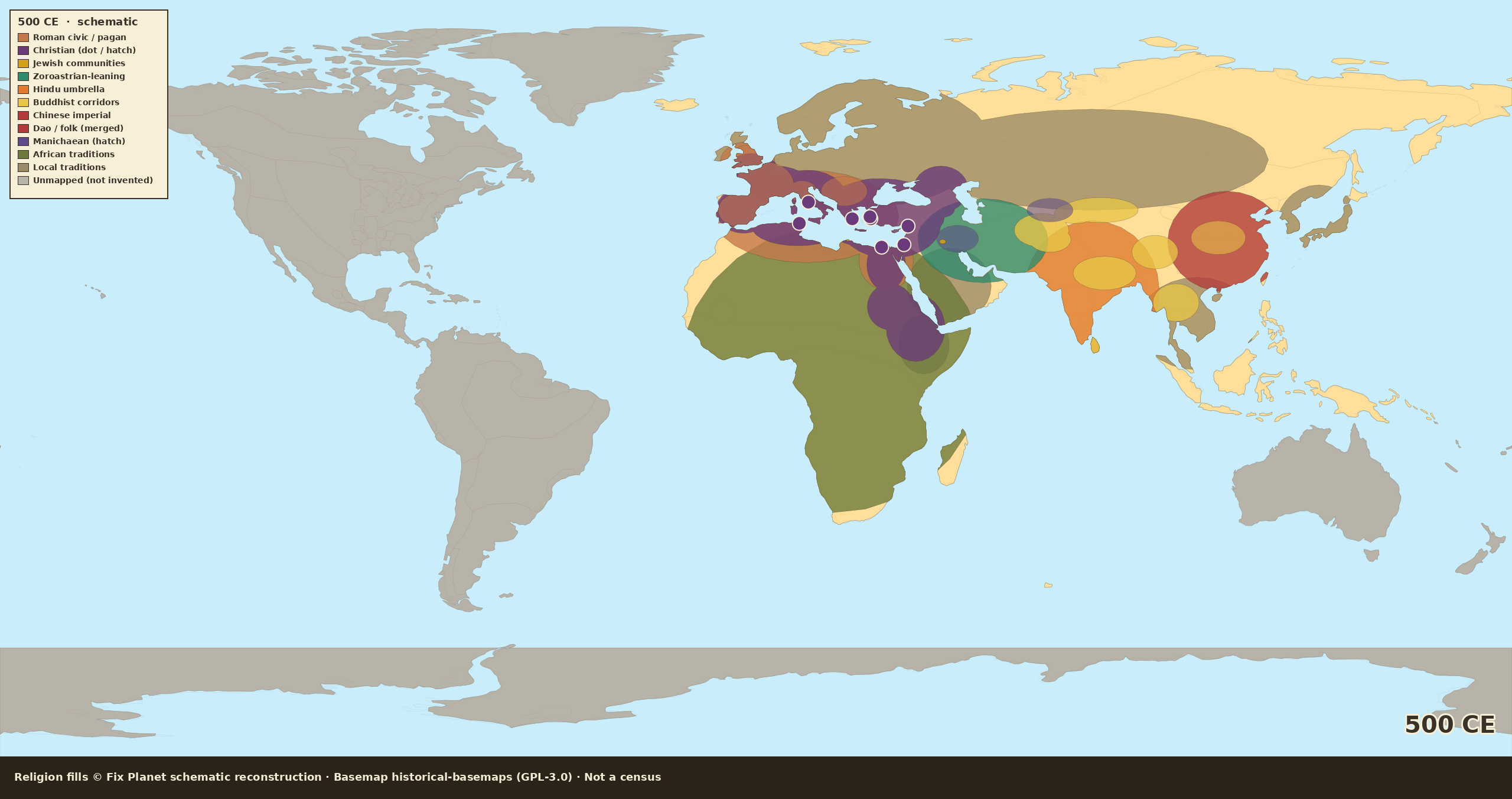
Schematic world religion map for 500 CE: Christian fill across much of the former Roman world, rural pagan hatch, Zoroastrian Iran, Indic and Chinese belts, Americas unmapped
Fix Planet schematic reconstruction. Map dated: 500 CE schematic.
Schematic reconstructionNot a censusOld World focusAmericas not shown

500 CE: former Roman world, rural pagan still showing

Around 500 CE Christianity has widened across much of the former Roman world, while rural pagan practice still shows in places. Sasanian Iran stays Zoroastrian; India and China keep their own major belts; Aksum and Nubia appear only as a light Christian edge. Americas and Oceania stay unmapped: we do not invent fills. Islam is not on this sheet.

Fix Planet hand-authored schematic: Old World / Mediterranean focus; Americas and Oceania stay unmapped

By continent

Europe / Mediterranean

Expanding Christian fill in East and much of the West; rural pagan hatch where the plate shows it; Jewish communities as spots; northern fringe still local traditions.

Southwest Asia / Iran

Zoroastrian Sasanian core; Jewish spots in the Near East.

South / Central / East Asia

Hindu umbrella on India; Buddhist corridors; Chinese imperial.

Africa

North Africa tied to the Mediterranean Christian/pagan mix; Sahel-south = coarse African traditional wash; Aksum/Nubia = optional Christian edge.

Americas / Oceania

Not mapped.

Source

Fix Planet schematic reconstruction
Map dated: 500 CE schematic
Religion fills © Fix Planet (schematic reconstruction, not a census). Basemap: Historical Basemaps, André Ourednik, GPL-3.0 licence.

License

Schematic religion fills © Fix Planet. Historical Basemaps, André Ourednik, GPL-3.0 licence
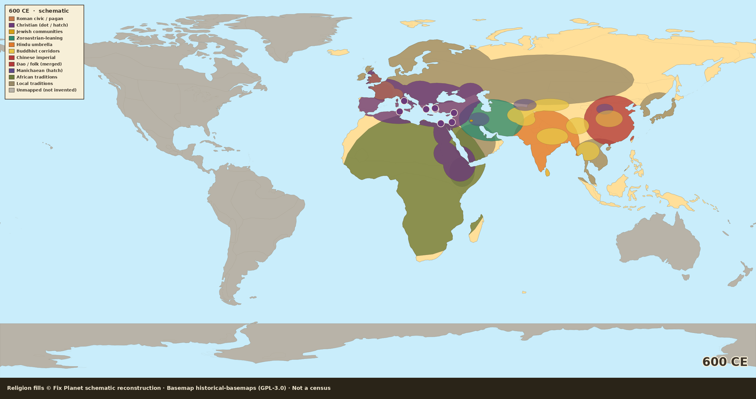
Schematic world religion map for 600 CE: wider Christian Mediterranean belt, Zoroastrian Iran, Hindu India, Buddhist corridors, Chinese imperial cult, Americas unmapped
Fix Planet schematic reconstruction. Map dated: 600 CE schematic.
Schematic reconstructionNot a censusOld World focusAmericas not shown

600 CE: stronger Christian belt, Iran still Zoroastrian

By 600 CE the Christian belt across Afro-Eurasia’s Mediterranean world is stronger, but this sheet still shows Zoroastrian Iran, Hindu India, Buddhist corridors, and China’s imperial cult. Islam has not expanded as an empire colour here. Americas stay unmapped. For the one-tradition process map of Christianity to 600, see the companion plate.

Fix Planet hand-authored schematic: Old World / Mediterranean focus; Americas and Oceania stay unmapped

By continent

Europe

Wider Christian presence East and West; rural pagan remnants where shown; Jewish spots; far north still local traditions.

SW Asia / Iran

Zoroastrian Iran still the main colour; Arabia without an Islamic empire wash.

S/C/E Asia

Hindu India; Buddhist corridors; Chinese imperial / folk.

Africa

Stronger Christian mark on Egypt and Roman Africa; Aksum/Nubia edge; south of Sahara = traditional wash.

Americas / Oceania

Not mapped.

Also: Christianity spread → 600 (process)

Source

Fix Planet schematic reconstruction
Map dated: 600 CE schematic
Religion fills © Fix Planet (schematic reconstruction, not a census). Basemap: Historical Basemaps, André Ourednik, GPL-3.0 licence. Process companion: Christianity spread to AD 600 (CC BY-SA 3.0).

License

Schematic religion fills © Fix Planet. Historical Basemaps, André Ourednik, GPL-3.0 licence
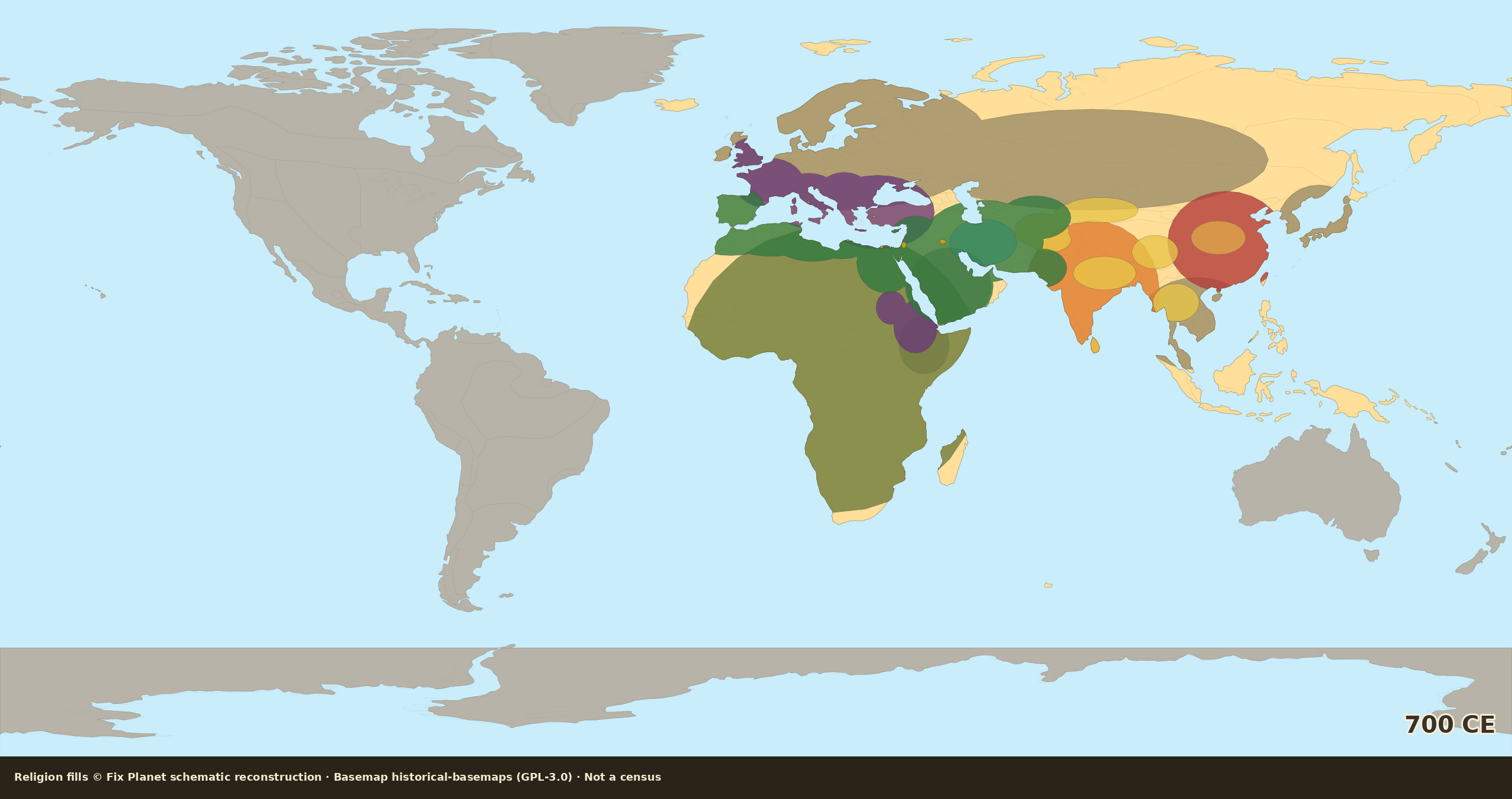
Schematic world religion map for 700 CE: first wide Islamic Umayyad belt from Iberia and the Maghreb through Egypt and Arabia to Iran, Transoxiana and Sind, Christian Byzantium Italy Frankish core and Britain, Hindu India, Americas unmapped
Fix Planet schematic reconstruction. Map dated: 700 CE schematic.
Schematic reconstructionNot a censusOld World focusAmericas unmapped

700 CE: first wide Islamic Umayyad belt

Around 700 CE the plate first shows a wide Islamic Umayyad belt: Iberia and the Maghreb through Egypt and Arabia to Iran, Transoxiana, and Sind. Christianity holds Byzantium, Italy, the Frankish core, and Britain; northern and eastern Europe stay local traditions. India keeps a Hindu umbrella; Buddhist corridors and China keep their belts. Americas and Oceania stay unmapped.

Fix Planet hand-authored schematic: Old World / Mediterranean focus; Americas and Oceania stay unmapped

By continent

Europe / Mediterranean

Christian fill in Byzantium, Italy, the Frankish core, and Britain. Iberia is Islamic. North and east Europe stay local traditions.

Southwest Asia / Iran

Umayyad Islamic wash from the Levant through Arabia and Iran to Transoxiana and Sind. Thin Zoroastrian remnant hatch in Iran.

South / Central / East Asia

Hindu umbrella on India; Buddhist corridors; Chinese imperial / folk.

Africa

Umayyad Islamic wash on the Maghreb, including Libya, and Egypt. Aksum and Nubia a light Christian edge. South of the Sahara a coarse African traditional wash.

Americas / Oceania

Not mapped.

Source

Fix Planet schematic reconstruction
Map dated: 700 CE schematic
Religion fills © Fix Planet (schematic reconstruction, not a census). Basemap: Historical Basemaps, André Ourednik, GPL-3.0 licence.

License

Schematic religion fills © Fix Planet. Historical Basemaps, André Ourednik, GPL-3.0 licence
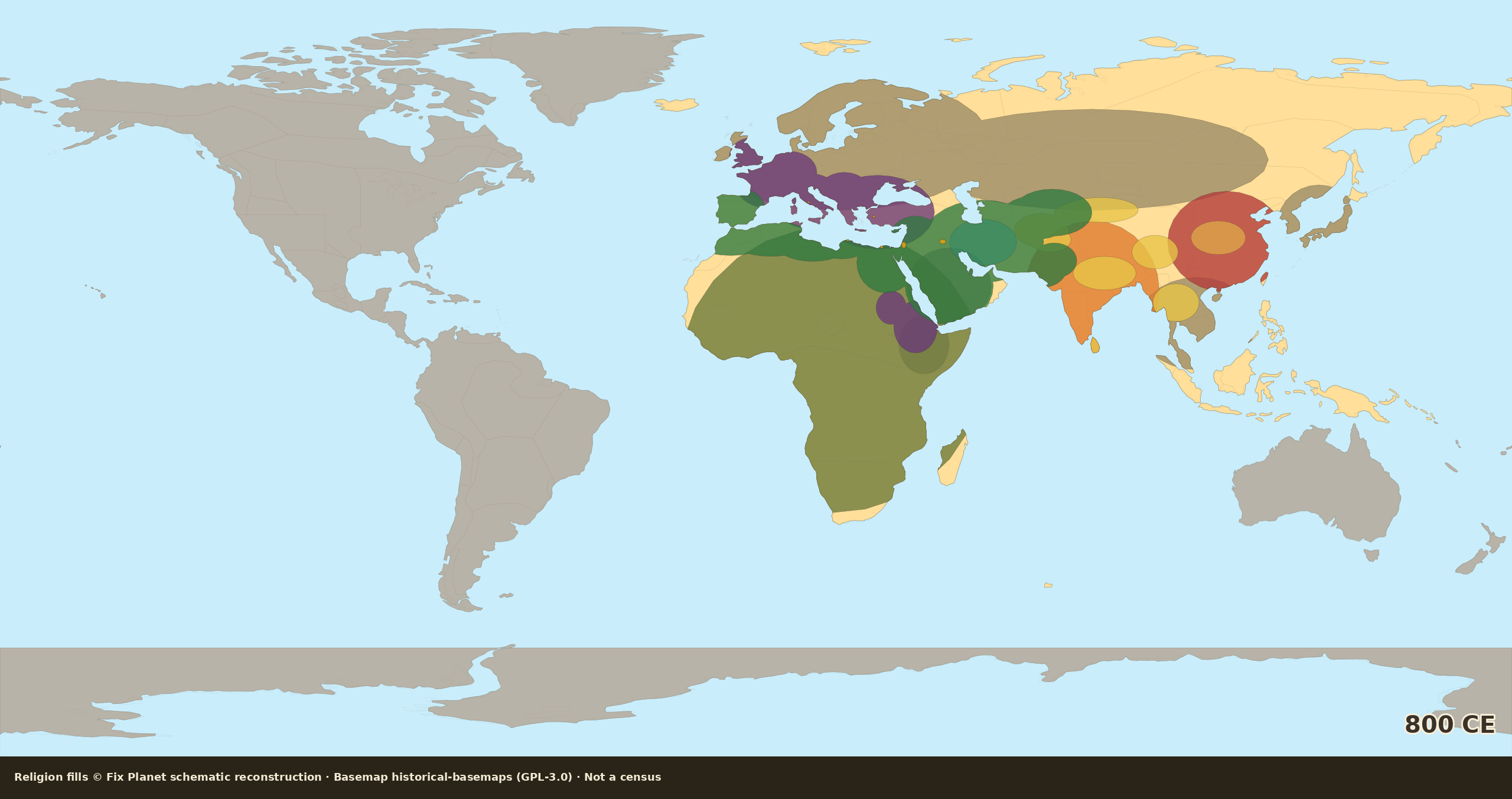
Schematic world religion map for 800 CE: Abbasid Islamic belt fuller in the east, stronger Frankish Carolingian Christian west, Hindu India, Americas unmapped
Fix Planet schematic reconstruction. Map dated: 800 CE schematic.
Schematic reconstructionNot a censusOld World focusAmericas unmapped

800 CE: Abbasid belt, stronger Frankish west

By 800 CE the Islamic belt is Abbasid, same Mediterranean-to-Iran wash, a little fuller in the east; al-Andalus and the Maghreb still on the plate. In the west, Frankish / Carolingian Christianity is stronger; Scandinavia and the Slavic east stay local. India Hindu; Buddhism and the Chinese imperial layer hold the East. Americas unmapped.

Fix Planet hand-authored schematic: Old World / Mediterranean focus; Americas and Oceania stay unmapped

By continent

Europe / Mediterranean

Stronger Frankish / Carolingian Christian west. Byzantium, Italy, and Britain stay Christian. Iberia remains Islamic. Scandinavia and the Slavic east stay local traditions.

Southwest Asia / Iran

Abbasid Islamic belt: the same Mediterranean-to-Iran wash, a little fuller in the east. Thin Zoroastrian remnant hatch in Iran. Al-Andalus and the Maghreb stay on the plate.

South / Central / East Asia

Hindu India; Buddhist corridors; Chinese imperial / folk.

Africa

Abbasid-era Islamic wash on the Maghreb and Egypt. Aksum and Nubia a light Christian edge. South of the Sahara a coarse African traditional wash.

Americas / Oceania

Not mapped.

Source

Fix Planet schematic reconstruction
Map dated: 800 CE schematic
Religion fills © Fix Planet (schematic reconstruction, not a census). Basemap: Historical Basemaps, André Ourednik, GPL-3.0 licence.

License

Schematic religion fills © Fix Planet. Historical Basemaps, André Ourednik, GPL-3.0 licence
Schematic world religion map for 900 CE: wide Abbasid-successor Islamic belt, Christian Latin West and Balkans, stronger Buddhist Southeast Asia, Americas unmapped
Fix Planet schematic reconstruction. Map dated: 900 CE schematic.
Schematic reconstructionNot a censusOld World focusAmericas unmapped

900 CE: Abbasid successors, Christian Europe still open north

Around 900 CE the Islamic West and Abbasid-successor belt stay wide: Maghreb, Egypt, Arabia, Iran, Central Asia, Sind; al-Andalus holds. Christian Europe is Byzantium plus the Latin West and the Balkans, still not solid Scandinavia, Baltic, or steppe north. East: Hindu India, stronger Buddhist Southeast Asia, Chinese imperial layer. Americas unmapped.

Fix Planet hand-authored schematic: Old World / Mediterranean focus; Americas and Oceania stay unmapped

By continent

Europe / Mediterranean

Christian Europe is Byzantium plus the Latin West and the Balkans, still not solid Scandinavia, Baltic, or steppe north. Al-Andalus holds as Islamic.

Southwest Asia / Iran

Abbasid-successor Islamic belt stays wide through Arabia, Iran, Central Asia, and Sind. Thin Zoroastrian remnant hatch in Iran.

South / Central / East Asia

Hindu India; stronger Buddhist Southeast Asia; Chinese imperial / folk.

Africa

Islamic Maghreb and Egypt. Aksum and Nubia a light Christian edge. South of the Sahara a coarse African traditional wash, no deep Sahel Islam yet.

Americas / Oceania

Not mapped.

Source

Fix Planet schematic reconstruction
Map dated: 900 CE schematic
Religion fills © Fix Planet (schematic reconstruction, not a census). Basemap: Historical Basemaps, André Ourednik, GPL-3.0 licence.

License

Schematic religion fills © Fix Planet. Historical Basemaps, André Ourednik, GPL-3.0 licence
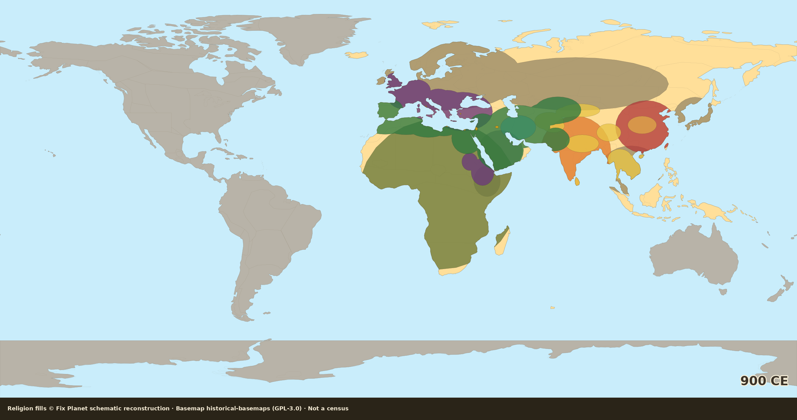
Schematic world religion map for 1000 CE: wide Islamic Maghreb, Libya, Egypt and the Near East belt, Christian Europe expanding north and east, Americas unmapped
Fix Planet schematic reconstruction. Map dated: 1000 CE schematic.
Schematic reconstructionNot a censusOld World focusAmericas unmapped

1000 CE: schematic reconstruction

Around 1000 CE a wide Islamic belt still holds the Maghreb, Libya, Egypt and the Near East, Arabia, Iran, Central Asia, and Sind; al-Andalus stays, with a light Sahel edge. Christian Europe pushes further north and east, Saxon / Polish / Kievan fringe, still not solid Scandinavia or the Baltic. India Hindu; Buddhist corridors and the Chinese imperial layer hold the East. Americas unmapped.

Fix Planet hand-authored schematic: Old World / Mediterranean focus; Americas and Oceania stay unmapped

By continent

Europe / Mediterranean

Wider Christian west and center (Germany / Saxon push, Bohemia and Poland fringe, Kievan Christian edge) plus Byzantine east, Italy, Britain; Iberia Islamic. Far north / Viking lands and Baltic pockets still local traditions. Jewish spots where shown.

Southwest Asia / North Africa / Iran

Islamic Maghreb, Libya, Egypt and the Near East belt through Arabia into Iran, Central Asia, and Sind; al-Andalus held; light Sahel / West Africa trade edge. Thin Zoroastrian remnant hatch; Manichaean minority hatch smaller where shown.

South / Central / East Asia

Hindu umbrella on India; Buddhist corridors much as at 900 (Silk Road, SE Asia stronger); Chinese imperial / folk belt. Far north steppe and island fringes stay local wash.

Africa

the Maghreb, Libya and Egypt in the Islamic belt; light Sahel trade edge; Aksum/Nubia Christian edge; south of the Sahara = coarse African traditional wash.

Americas / Oceania

Not mapped.

Source

Fix Planet schematic reconstruction
Map dated: 1000 CE schematic
1. Religion fills: Fix Planet schematic reconstruction (not a census). 2. Historical Basemaps, André Ourednik, GPL-3.0 licence. 3. Land mask: Natural Earth 110m. 4. Orientation only: medieval Afro-Eurasian religion surveys.

License

Schematic religion fills © Fix Planet. Historical Basemaps, André Ourednik, GPL-3.0 licence
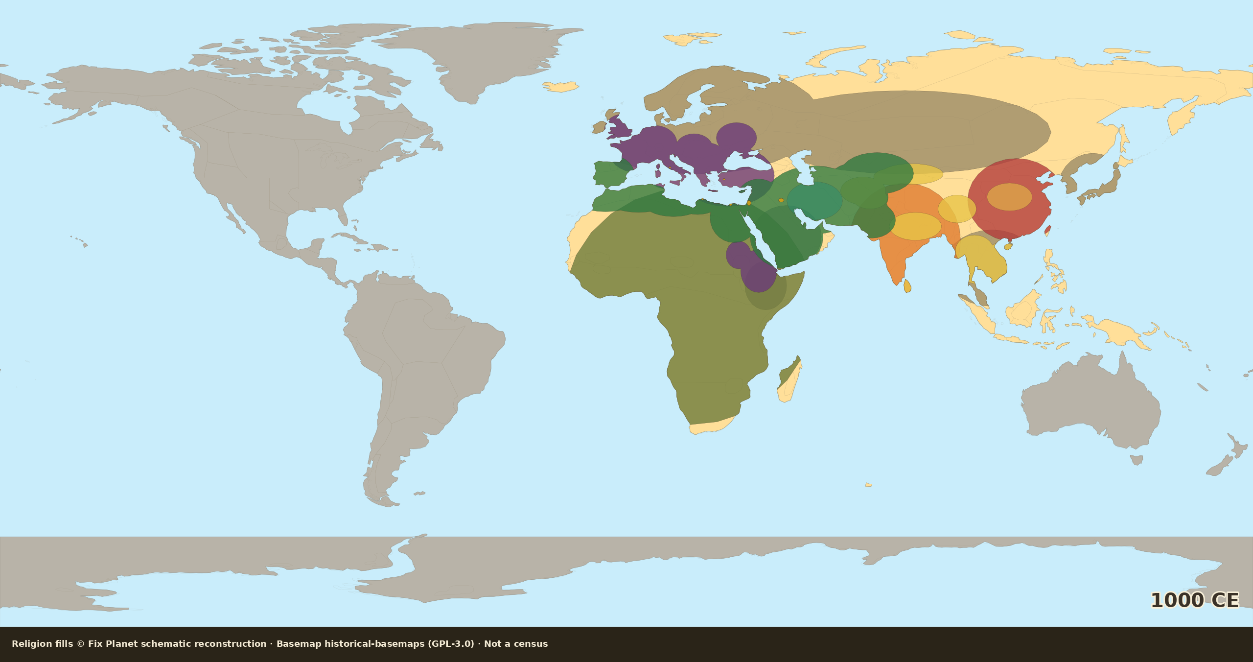
Schematic world religion map for 1100 CE: wide Islamic belt, Crusader Levant foothold, stronger Buddhist Tibet and Southeast Asia, Americas unmapped
Fix Planet schematic reconstruction. Map dated: 1100 CE schematic.
Schematic reconstructionNot a censusOld World focusAmericas unmapped

1100 CE: schematic reconstruction

By 1100 CE (Crusades era) the Islamic belt stays wide: Maghreb, Libya, Egypt, Levant, Arabia, Iran, Central Asia, al-Andalus; Sahel edge. Latin Christian West and Byzantium stronger; schematic Crusader Levant foothold. Northern and eastern Europe still partly local. India Hindu; stronger Buddhist Tibet / Southeast Asia / China inroads. Americas unmapped.

Fix Planet hand-authored schematic: Old World / Mediterranean focus; Americas and Oceania stay unmapped

By continent

Europe / Mediterranean

Fuller Christian Rhineland / Germany, Bohemia and Poland fringe, Balkans / Byzantine, Italy; schematic Crusader Levant foothold. Iberia still Islamic. Far north residual and Baltic / Finnic pockets = local traditions. Jewish spots.

Southwest Asia / North Africa / Iran

Islamic Maghreb, Libya, Egypt, the Levant, Arabia, the Near East, Persia and Central Asia fringe; al-Andalus held; Sahel edge. Thin Zoroastrian remnant hatch only.

South / Central / East Asia

Hindu India; Buddhist corridors stronger (Tibet / Himalaya fringe, SE Asia, China inroads); Chinese imperial / folk belt. Northern steppe and island fringes = local wash.

Africa

the Maghreb, Libya and Egypt Islamic; Sahel trade edge; Aksum/Nubia Christian edge; Sahel-south = African traditional wash.

Americas / Oceania

Not mapped.

Source

Fix Planet schematic reconstruction
Map dated: 1100 CE schematic
1. Religion fills: Fix Planet schematic reconstruction (not a census). 2. Historical Basemaps, André Ourednik, GPL-3.0 licence. 3. Land mask: Natural Earth 110m. 4. Orientation only: high-medieval Afro-Eurasian religion surveys.

License

Schematic religion fills © Fix Planet. Historical Basemaps, André Ourednik, GPL-3.0 licence
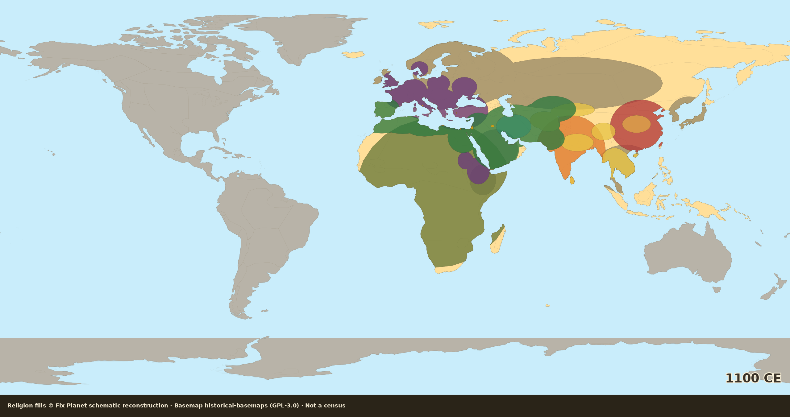
Schematic world religion map for 1200 CE: major Islamic belt, Christian Baltics and Scandinavia fringe, Americas unmapped
Fix Planet schematic reconstruction. Map dated: 1200 CE schematic.
Schematic reconstructionNot a censusOld World focusAmericas unmapped

1200 CE: schematic reconstruction

Around 1200 CE (Mongol eve) the same major Islamic belt: the Maghreb, Libya, Egypt, the Near East, Iran and Central Asia, al-Andalus, Indus edge and Sahel edge, no invented new empire wash. Christianity a bit further into the Baltics and Scandinavia; still not all Europe solid. India Hindu; Buddhism and the Chinese imperial layer hold the East. Americas unmapped.

Fix Planet hand-authored schematic: Old World / Mediterranean focus; Americas and Oceania stay unmapped

By continent

Europe / Mediterranean

Further Christian Baltic / Scandinavia fringe and east-Elbe / Rus hold; Latin West, Byzantium, Italy solid on the plate. Iberia Islamic. Far Arctic / Finnic residual still local traditions. Jewish spots.

Southwest Asia / North Africa / Iran

Same major Islamic belt as 1100, plus Indus / Multan hold and a slight Sahel trade edge: the Maghreb, Libya, Egypt, the Near East, Persia and Central Asia; al-Andalus. Thin Zoroastrian remnant hatch only.

South / Central / East Asia

Hindu India; Buddhist corridors as at 1100 (Tibet, SE Asia, China inroads); Chinese imperial / folk belt. Northern steppe and island fringes = local wash.

Africa

the Maghreb, Libya and Egypt Islamic; slight Sahel trade edge; Aksum/Nubia Christian edge; Sahel-south = African traditional wash.

Americas / Oceania

Not mapped.

Source

Fix Planet schematic reconstruction
Map dated: 1200 CE schematic
1. Religion fills: Fix Planet schematic reconstruction (not a census). 2. Historical Basemaps, André Ourednik, GPL-3.0 licence. 3. Land mask: Natural Earth 110m. 4. Orientation only: high-medieval Afro-Eurasian religion surveys.

License

Schematic religion fills © Fix Planet. Historical Basemaps, André Ourednik, GPL-3.0 licence
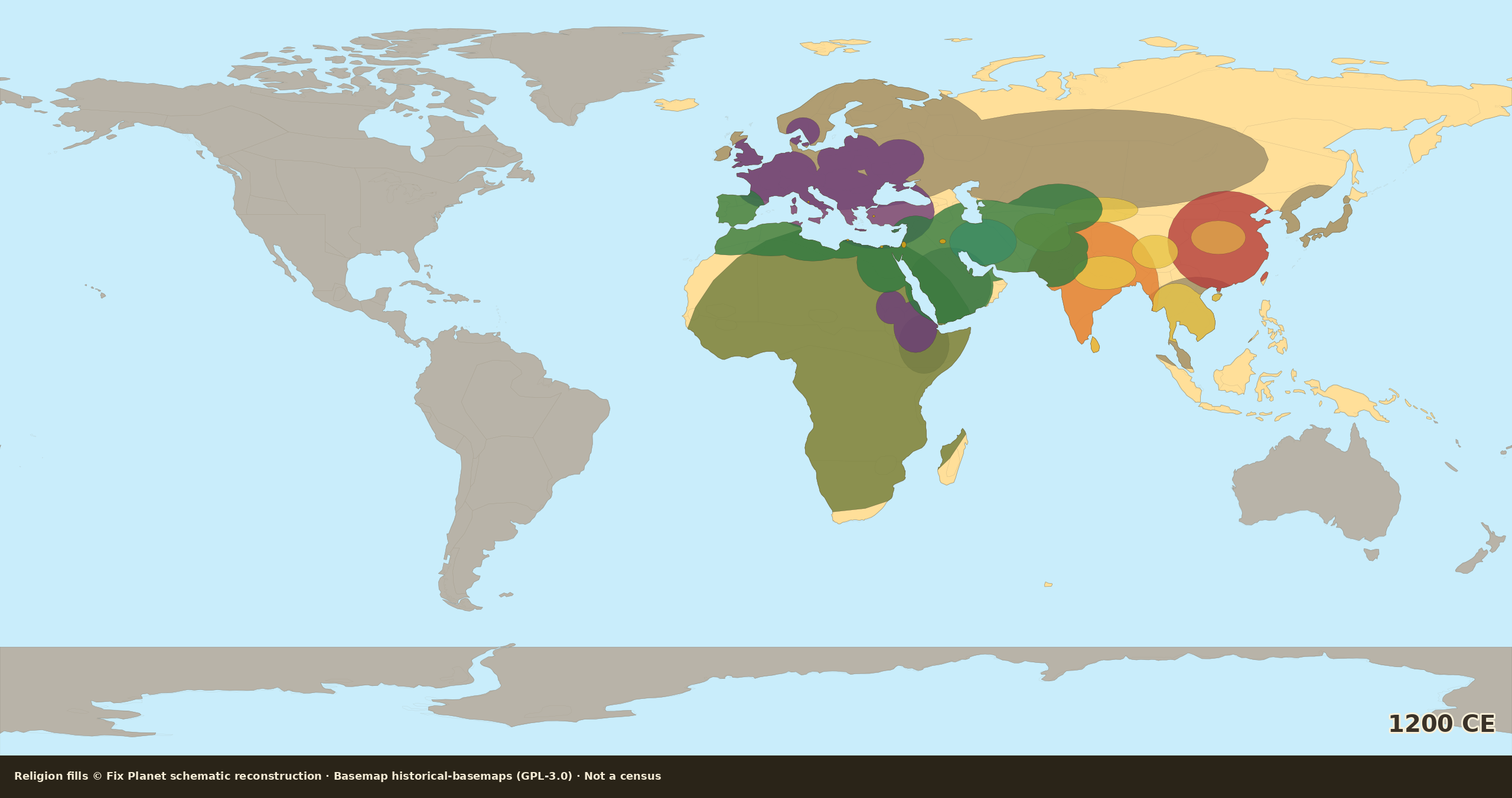
Schematic world religion map for 1300 CE: Mamluk Islamic belt, Anatolia fringe, Granada pocket, Americas indigenous fill
Fix Planet schematic reconstruction. Map dated: 1300 CE schematic.
Schematic reconstructionNot a censusAmericas indigenous fillColonial edge 1500

1300 CE: schematic reconstruction

Around 1300 CE the Islamic belt is Mamluk Egypt and Syria, Maghreb and Libya, an Anatolia fringe (early Ottoman), a Granada pocket in Iberia, plus the Near East, Arabia, Iran and Central Asia and a Delhi fringe. Christian Europe is nearly solid in the west and center; the Balkans stay Christian. India Hindu; Buddhist corridors and the Chinese layer hold the East. In the Americas, local traditions: rising Mesoamerica (Aztec) and the Andes, plus other indigenous zones.

Fix Planet hand-authored schematic: Old World / Mediterranean focus; Americas and Oceania stay unmapped

By continent

Europe / Mediterranean

Christian fill across Latin West, Italy, Britain, Scandinavia fringe, east-Elbe / Rus hold, and the Balkans. Iberia mostly Christian except the Granada Islamic pocket. Anatolia only an Islamic fringe, not majority wash. Jewish spots where shown.

Southwest Asia / North Africa / Iran

Mamluk Islamic Egypt and Syria / Levant; the Maghreb and Libya; Arabia, the Near East, Iran and Central Asia; Anatolia Islamic fringe (early Ottoman); Delhi / Indus fringe. Thin Zoroastrian remnant hatch only where marked.

South / Central / East Asia

Hindu umbrella on India (Delhi fringe Islamic on the northwest edge); Buddhist corridors (Tibet / SE Asia / China inroads); Chinese imperial / folk belt. Northern steppe and island fringes = local wash.

Africa

the Maghreb, Libya and Egypt in the Islamic belt; light Sahel trade edge; Christian Ethiopia/Nubia edge where shown; south of the Sahara = coarse African traditional wash.

Americas / Oceania

Local traditions across the Americas: rising Aztec / Mesoamerica and Andean highland cores, plus Amazon, North American plains, and southern-cone indigenous wash. Antarctica / Oceania unmapped.

Source

Fix Planet schematic reconstruction
Map dated: 1300 CE schematic
1. Religion fills: Fix Planet schematic reconstruction (not a census). 2. Historical Basemaps, André Ourednik, GPL-3.0 licence. 3. Land mask: Natural Earth 110m. 4. Orientation only: late-medieval Afro-Eurasian surveys (Mamluk / early Ottoman fringe / Granada) plus indigenous Americas (Aztec-rising Mesoamerica / Andes).

License

Schematic religion fills © Fix Planet. Historical Basemaps, André Ourednik, GPL-3.0 licence
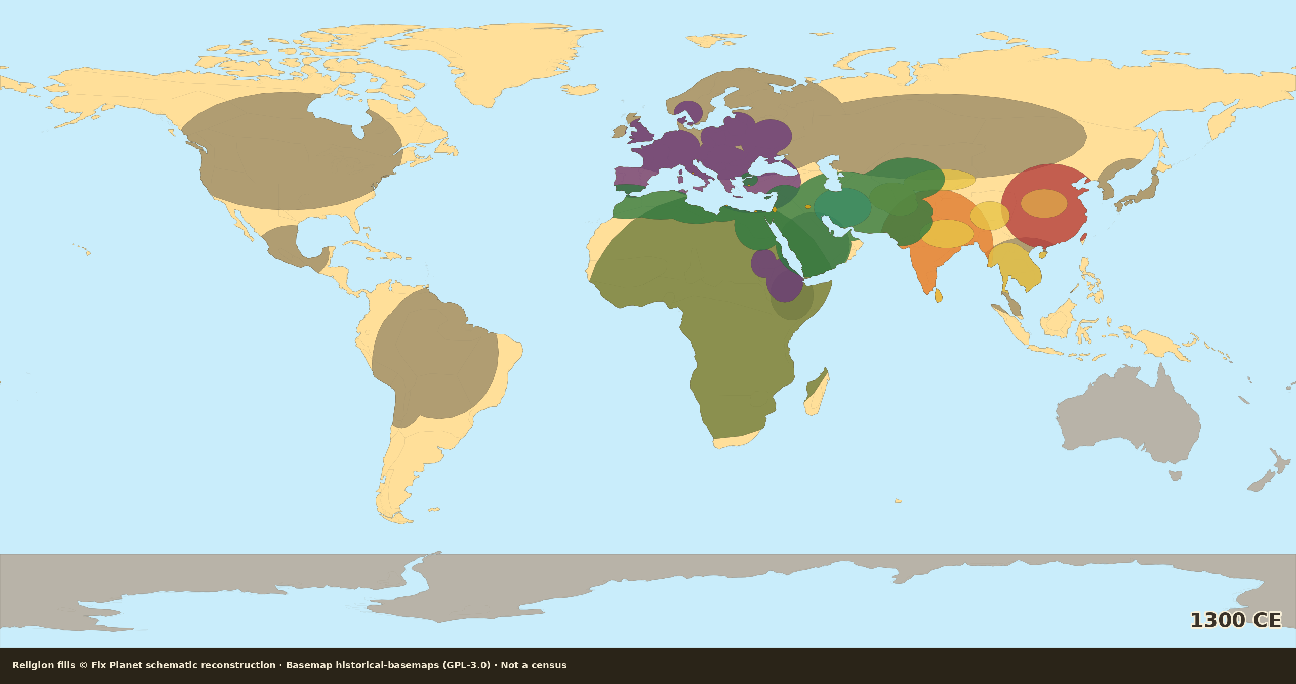
Schematic world religion map for 1400 CE: wider Islamic belt, Ottoman Anatolia, Granada pocket, Aztec and Inca cores
Fix Planet schematic reconstruction. Map dated: 1400 CE schematic.
Schematic reconstructionNot a censusAmericas indigenous fillColonial edge 1500

1400 CE: schematic reconstruction

By 1400 CE the Islamic belt is wider: Mamluk Egypt, Syria and the Levant, the Maghreb and Libya, the Timur zone (Central Asia / Iran / Near East), Anatolia already majority Islamic (Ottoman), Granada pocket still held. Christian Europe fuller; the Balkans still mostly Christian demographically. India Hindu; Buddhism and the Chinese layer hold the East. In the Americas, strong local cores: Aztec Mesoamerica and the Inca Andes, plus other indigenous zones.

Fix Planet hand-authored schematic: Old World / Mediterranean focus; Americas and Oceania stay unmapped

By continent

Europe / Mediterranean

Fuller Christian west, center, Scandinavia, Baltics, and Rus fringe; Balkans still mostly Christian demographically. Iberia Christian except Granada pocket. Anatolia majority Islamic (Ottoman), not a Byzantine Christian wash. Jewish spots.

Southwest Asia / North Africa / Iran

Islamic Maghreb, Libya, Egypt, the Levant and Arabia plus Timur-zone wash fuller into Iran and Central Asia; Anatolia majority Islamic (Ottoman). Granada pocket remains in Iberia. Thin Zoroastrian remnant hatch only.

South / Central / East Asia

Hindu India; Buddhist corridors as at 1300 (Tibet / SE Asia / China inroads); Chinese imperial / folk belt (Ming-era plate). Northern steppe and island fringes = local wash.

Africa

the Maghreb, Libya and Egypt Islamic; Sahel trade edge; Christian Ethiopia/Nubia edge where shown; Sahel-south = African traditional wash.

Americas / Oceania

Strong local traditions: Aztec Mesoamerica and Inca Andes cores, plus Amazon, North American plains, and southern-cone indigenous wash. Antarctica / Oceania unmapped.

Source

Fix Planet schematic reconstruction
Map dated: 1400 CE schematic
1. Religion fills: Fix Planet schematic reconstruction (not a census). 2. Historical Basemaps, André Ourednik, GPL-3.0 licence. 3. Land mask: Natural Earth 110m. 4. Orientation only: late-medieval Afro-Eurasian surveys (Timur; Ottoman Anatolia majority; Granada; Balkans Christian) plus Aztec Mesoamerica / Inca Andes.

License

Schematic religion fills © Fix Planet. Historical Basemaps, André Ourednik, GPL-3.0 licence
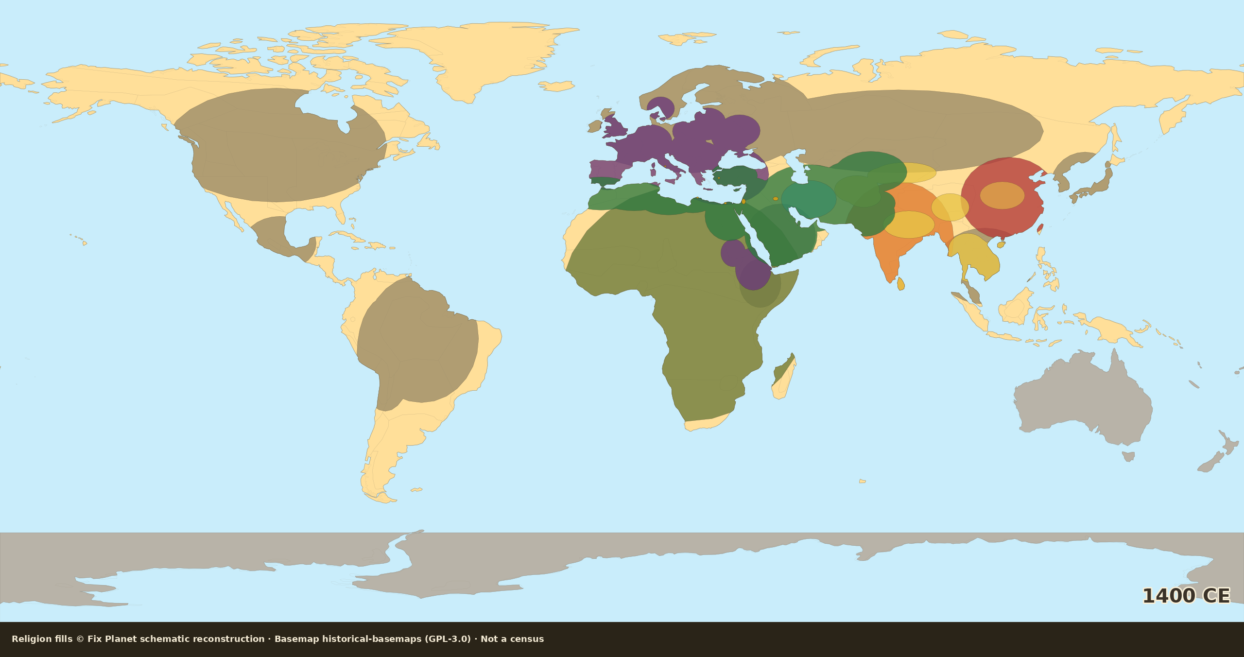
Schematic world religion map for 1500 CE: no Granada, Ottoman Anatolia, Balkans Christian, Aztec and Inca cores, light colonial edge
Fix Planet schematic reconstruction. Map dated: 1500 CE schematic.
Schematic reconstructionNot a censusAmericas indigenous fillColonial edge 1500

1500 CE: schematic reconstruction

Around 1500 CE no Granada: all Iberia Christian. The Islamic belt is the Maghreb, Libya, Egypt, the Levant, Arabia, Iran and Central Asia, and Anatolia roughly Muslim Ottoman (Constantinople 1453). The Balkans sit under Ottoman rule but the population is still mostly Christian, no solid Islamic wash across Southeast Europe. India Hindu; Buddhism and the Chinese layer hold the East. In the Americas, Aztec and Inca local-tradition cores remain; a light early Christian colonial edge appears in the Caribbean and on the Mexican coast.

Fix Planet hand-authored schematic: Old World / Mediterranean focus; Americas and Oceania stay unmapped

By continent

Europe / Mediterranean

Christian Iberia (post-Granada), Latin West, Italy, Scandinavia, Baltics, Rus fringe solid on the plate. Balkans under Ottoman rule but still mostly Christian demographically, only small Muslim pockets (Bosnia / Albania fringe) where marked. Anatolia majority Muslim Ottoman: Christian remnant on Aegean / west coast only, not inland. Jewish spots.

Southwest Asia / North Africa / Iran

Islamic Maghreb, Libya, Egypt, the Levant, Arabia, the Near East, Persia and Central Asia; Anatolia majority Muslim (Ottoman heartland after 1453). No Iberia / Granada fill. Thin Zoroastrian remnant hatch only.

South / Central / East Asia

Hindu India; Buddhist corridors as at 1300-1400 (Tibet / SE Asia / China inroads); Chinese imperial / folk belt. Northern steppe and island fringes = local wash.

Africa

the Maghreb, Libya and Egypt Islamic; Sahel trade edge; Christian Ethiopia/Nubia edge where shown; Sahel-south = African traditional wash.

Americas / Oceania

Aztec Mesoamerica and Inca Andes local-tradition cores still standing, plus Amazon / plains / southern-cone indigenous wash; light early Christian colonial edge on the Caribbean and coastal Mexico only. Antarctica / Oceania unmapped.

Source

Fix Planet schematic reconstruction
Map dated: 1500 CE schematic
1. Religion fills: Fix Planet schematic reconstruction (not a census). 2. Historical Basemaps, André Ourednik, GPL-3.0 licence. 3. Land mask: Natural Earth 110m. 4. Orientation only: early-modern Afro-Eurasian surveys (no Granada; Ottoman Anatolia roughly Muslim; Balkans Christian) plus Aztec and Inca Americas with an early Christian edge in the Caribbean and Mexico.

License

Schematic religion fills © Fix Planet. Historical Basemaps, André Ourednik, GPL-3.0 licence
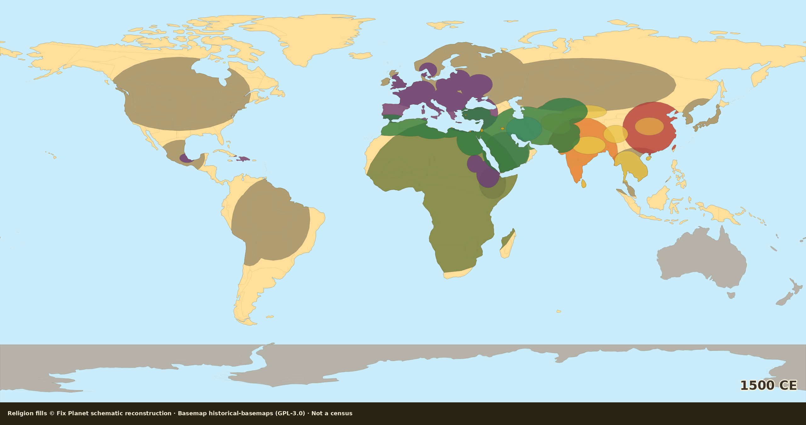
Schematic world religion map for 1600 CE: Ottoman Anatolia Islamic, Balkans Christian, Iberia Christian, Americas inland indigenous residual with a Christian colonial edge, Africa traditional south of the Sahara with Christian pockets, Australia Aboriginal
Fix Planet schematic reconstruction. Map dated: 1600 CE schematic.
Schematic reconstructionNot a censusAmericas ChristianizingAfrica Christian pockets

1600 CE: schematic reconstruction

Around 1600 CE Ottoman Anatolia is Islamic; the Balkans stay demographically Christian; Iberia is Christian. In the Americas, inland indigenous residual plus a Christian colonial edge (New Spain, Andes, Brazil, Caribbean). Africa: Islamic north/Sahel; south of the Sahara mostly African traditional, with Christian pockets in Ethiopia, Kongo, and Portuguese coasts. Australia: Aboriginal traditional (no colony yet).

Fix Planet hand-authored schematic: Old World / Mediterranean focus; Americas and Oceania stay unmapped

By continent

Europe / Mediterranean

Christian fill across Latin West, Italy, Britain, Scandinavia, Baltics, and the Rus fringe. Iberia Christian. Balkans stay demographically Christian, no solid Islamic wash of Southeast Europe. Anatolia Islamic (Ottoman). Jewish spots where shown.

Southwest Asia / North Africa / Iran

Islamic Maghreb, Libya, Egypt, the Levant, Arabia, the Near East, Persia and Central Asia; Anatolia Islamic (Ottoman heartland). Sahel and Swahili coasts in the Islamic belt. Thin Zoroastrian remnant hatch only where marked.

South / Central / East Asia

Hindu umbrella on India; Buddhist corridors (Tibet / SE Asia / China inroads); Chinese imperial / folk belt. Northern steppe and island fringes = local wash.

Africa

the Maghreb, Egypt, Sahel and Swahili in the Islamic belt. South of the Sahara mostly African traditional. Christian pockets only: Ethiopia, Kongo, and Portuguese coasts. No Madagascar Christian fill.

Americas / Oceania

Inland indigenous residual across much of the Americas, plus a Christian colonial edge (New Spain, Andes, Brazil, Caribbean). No Aztec or Inca empire wash. Australia Aboriginal traditional, no colony yet. Pacific islands unmapped.

Source

Fix Planet schematic reconstruction
Map dated: 1600 CE schematic
1. Religion fills: Fix Planet schematic reconstruction (not a census). 2. Historical Basemaps, André Ourednik, GPL-3.0 licence. 3. Land mask: Natural Earth 110m. 4. Orientation only: Ottoman Anatolia Islamic; Balkans demographically Christian; Americas Christianizing (inland residual and a colonial edge); Africa Christian pockets only.

License

Schematic religion fills © Fix Planet. Historical Basemaps, André Ourednik, GPL-3.0 licence
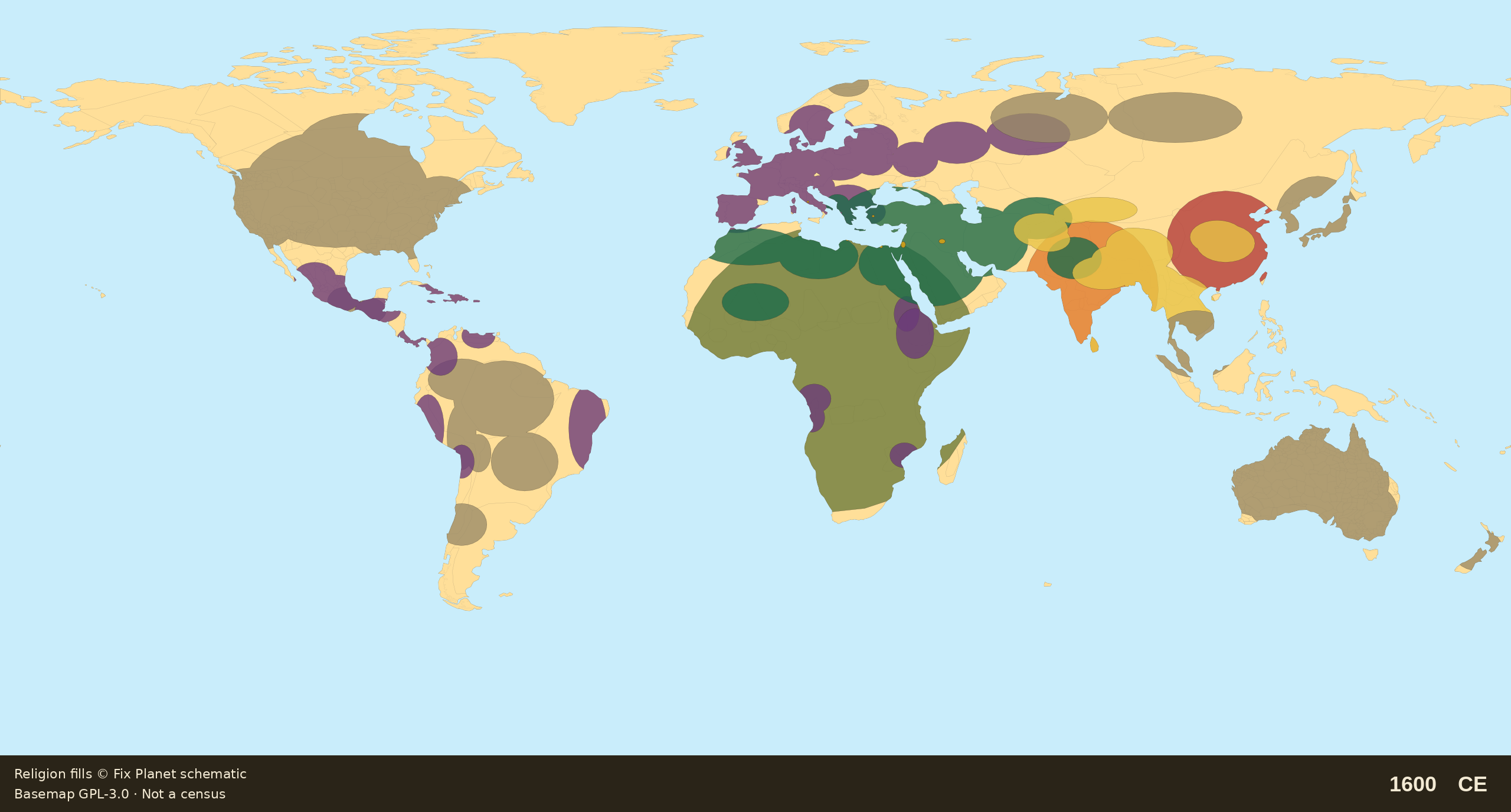
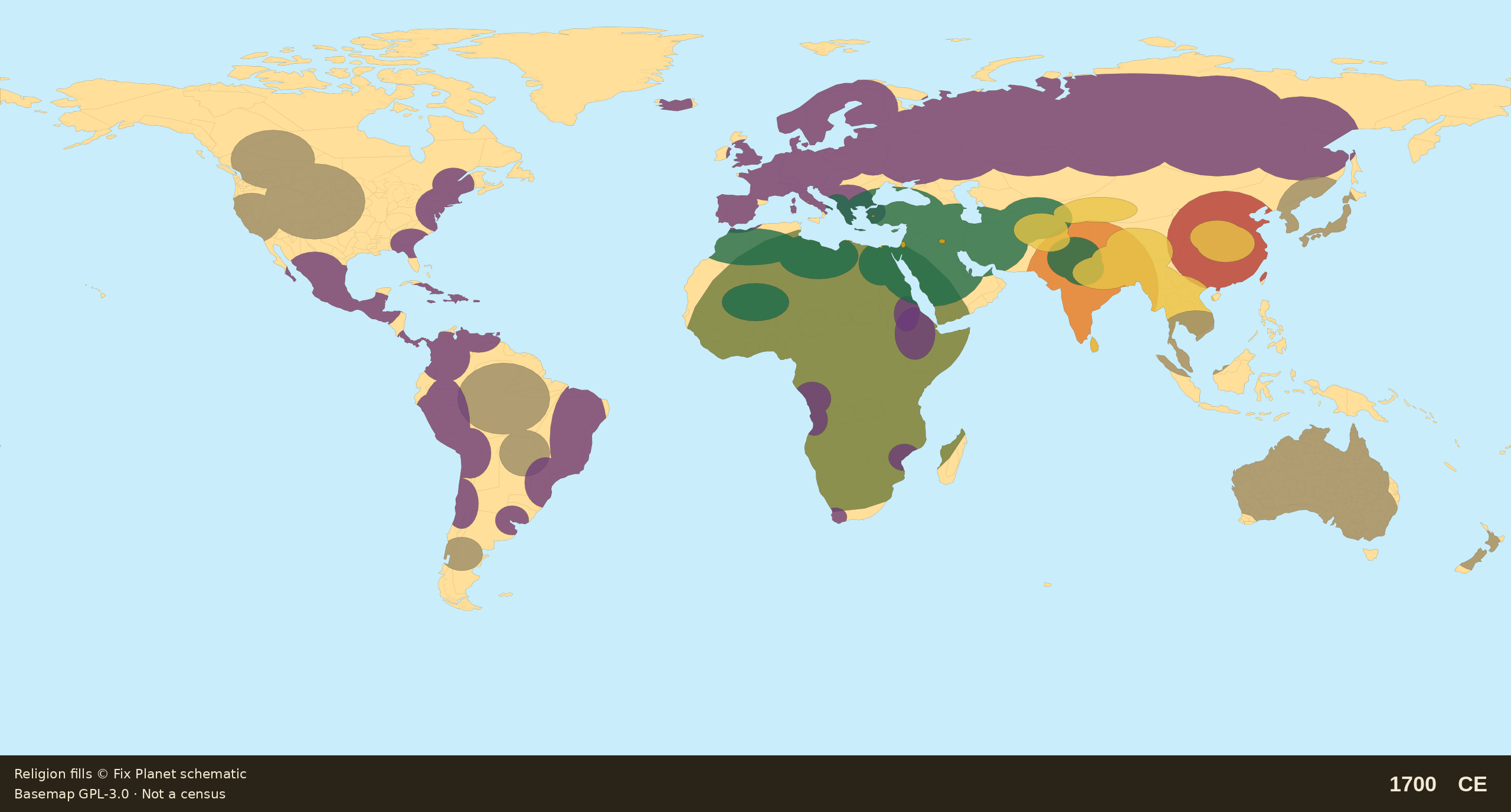
Schematic world religion map for 1700 CE: Iberian America largely Christian, British and French eastern North America Christian, inland residual, Orthodox Siberia belt, Lutheran Scandinavia, Cape Colony, Australia Aboriginal
Fix Planet schematic reconstruction. Map dated: 1700 CE schematic.
Schematic reconstructionNot a censusAmericas ChristianizingAfrica Christian pockets

1700 CE: schematic reconstruction

Around 1700 CE Iberian America is largely baptized (public Christian majority); British/French eastern North America is Christian; inland residual remains. Russia is an Orthodox empire with a Siberia belt; Scandinavia is solid Lutheran state-church. Africa: same Christian pockets plus the Cape Colony (from 1652). Australia still Aboriginal traditional.

Fix Planet hand-authored schematic: Old World / Mediterranean focus; Americas and Oceania stay unmapped

By continent

Europe / Mediterranean

Scandinavia a solid Lutheran state-church wash. Russia an Orthodox empire with a Siberia belt. Iberia Christian. Balkans still demographically Christian, no solid Islamic wash of Southeast Europe. Anatolia Islamic (Ottoman). Jewish spots.

Southwest Asia / North Africa / Iran

Islamic Maghreb, Libya, Egypt, the Levant, Arabia, the Near East, Persia and Central Asia; Anatolia Islamic (Ottoman). Sahel and Swahili coasts in the Islamic belt. Thin Zoroastrian remnant hatch only.

South / Central / East Asia

Hindu India; Buddhist corridors (Tibet / SE Asia / China inroads); Chinese imperial / folk belt. Northern steppe and island fringes = local wash.

Africa

Same Christian pockets as 1600 (Ethiopia, Kongo, Portuguese coasts) plus the Cape Colony (from 1652). the Maghreb, Egypt, Sahel and Swahili Islamic. South of the Sahara mostly African traditional. No Madagascar Christian.

Americas / Oceania

Iberian America largely baptized (public Christian majority). British/French eastern North America Christian; inland residual remains. No Aztec or Inca empire wash. Australia still Aboriginal traditional. Pacific islands unmapped.

Source

Fix Planet schematic reconstruction
Map dated: 1700 CE schematic
1. Religion fills: Fix Planet schematic reconstruction (not a census). 2. Historical Basemaps, André Ourednik, GPL-3.0 licence. 3. Land mask: Natural Earth 110m. 4. Orientation only: Americas Christianizing; Orthodox Russia and Lutheran Scandinavia; Cape Colony from 1652; Australia Aboriginal.

License

Schematic religion fills © Fix Planet. Historical Basemaps, André Ourednik, GPL-3.0 licence
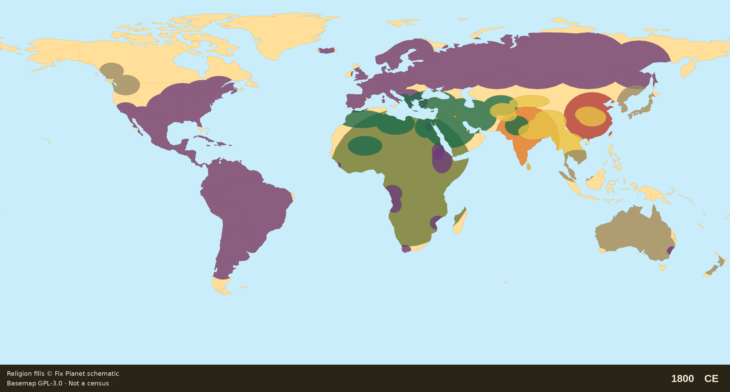
Schematic world religion map for 1800 CE: South America nearly Catholic, North America Christian east-center, Russia Orthodox to the Pacific, Lutheran Scandinavia, Africa Christian pockets, tiny NSW colony, Australia Aboriginal
Fix Planet schematic reconstruction. Map dated: 1800 CE schematic.
Schematic reconstructionNot a censusAmericas ChristianizingAfrica Christian pockets

1800 CE: schematic reconstruction

Around 1800 CE (Napoleonic / independence eve): South America nearly monolithic Catholic; North America Christian east-center (Protestant US, Catholic Quebec/Mexico). Russia Orthodoxy to the Pacific; Scandinavia Lutheran. Africa still pockets (Ethiopia, Kongo, Angola/Mozambique, Cape; tiny Freetown and Coptic residual). Australia: tiny NSW colony at Sydney (from 1788), continent Aboriginal.

Fix Planet hand-authored schematic: Old World / Mediterranean focus; Americas and Oceania stay unmapped

By continent

Europe / Mediterranean

Scandinavia Lutheran. Russia Orthodoxy to the Pacific. Iberia Christian. Balkans still demographically Christian, no solid Islamic wash of Southeast Europe. Anatolia Islamic (Ottoman). Jewish spots.

Southwest Asia / North Africa / Iran

Islamic Maghreb, Libya, Egypt, the Levant, Arabia, the Near East, Persia and Central Asia; Anatolia Islamic (Ottoman). Sahel and Swahili coasts in the Islamic belt. Tiny Coptic residual in Egypt where marked. Thin Zoroastrian remnant hatch only.

South / Central / East Asia

Hindu India; Buddhist corridors (Tibet / SE Asia / China inroads); Chinese imperial / folk belt. Northern steppe and island fringes = local wash.

Africa

Still Christian pockets only: Ethiopia, Kongo, Angola/Mozambique, Cape; tiny Freetown and a Coptic residual. the Maghreb, Egypt, Sahel and Swahili Islamic. South of the Sahara mostly African traditional. No Madagascar Christian.

Americas / Oceania

South America nearly monolithic Catholic. North America Christian east-center (Protestant US, Catholic Quebec/Mexico); northwest residual remains. No Aztec or Inca empire wash. Australia: tiny NSW colony at Sydney (from 1788); the continent stays Aboriginal traditional. Pacific islands unmapped.

Source

Fix Planet schematic reconstruction
Map dated: 1800 CE schematic
1. Religion fills: Fix Planet schematic reconstruction (not a census). 2. Historical Basemaps, André Ourednik, GPL-3.0 licence. 3. Land mask: Natural Earth 110m. 4. Orientation only: Napoleonic and independence-eve Americas; Orthodoxy to the Pacific; African pockets; a New South Wales speck from 1788.

License

Schematic religion fills © Fix Planet. Historical Basemaps, André Ourednik, GPL-3.0 licence